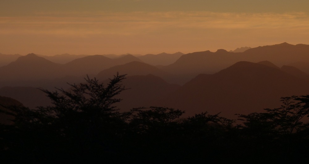
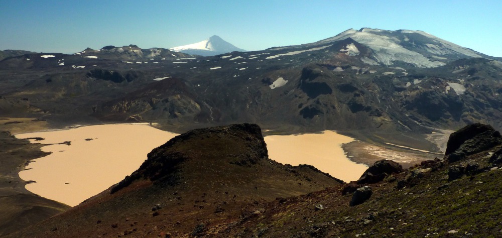
On 6 November an earthquake swarm started on the eastern size of the Askja volcano, which is in the uninhabited interior of Iceland. At the time of writing (14 November, 12 days later), the swarm is continuing and to date there have been over 1,200 earthquakes.
So, might this lead to an eruption or is it purely tectonic (i.e. earth movement)? Is this normal for this part of Iceland? Is there any link to climate change? How do I find out more? I’ll try and answer these questions in this and subsequent blog entries, but for now I’m going to deal with useful information sources.
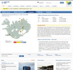
The Icelanders have an enviable reputation of excellent monitoring their natural hazards – especially volcanic and seismic activity. A key resource is the Icelandic Meteorological Office (IMO). I know, it sounds a bit odd that an organisation with ‘weather’ in the title is an important hub for volcanic and earthquake monitoring, but this is a historical quirk and you know what – it works rather well. Especially as there is generally excellent cooperation between the other agencies that also have responsibilities for volcano and earthquake monitoring.
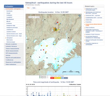
The IMO home page is here and this usually contains a summary of what’s been happening with earthquakes – either a summary of last week’s activity, and sometimes (as at present) an expert comment on an ongoing earthquake swarm. When there’s an eruption, this page contains great updates. This is what this page looks like:
Now, if you click on the map of Iceland with earthquakes then you’ll go here where there’s more information. And here’s this page:
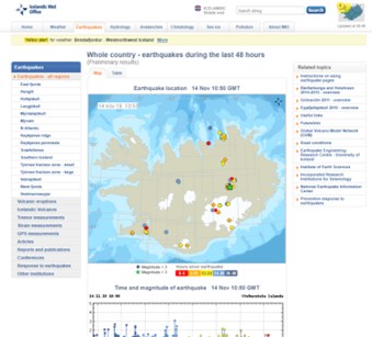
Here you can select regions on the left, and if you click the Vatnajökull one you go to this page Here you will see a map showing the locations of earthquakes, and below this a graphic showing earthquakes against time. This is a useful graphic as it shows earthquake magnitude as well. This is the Vatnajökull page:
This is as far as most people go, and for most it is sufficient. But if you want to drill a little further then read on.
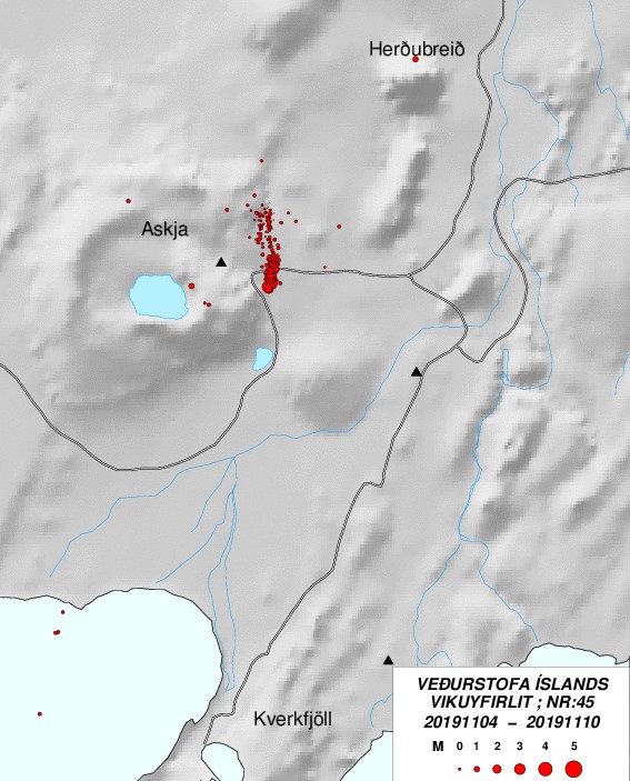
Each volcanic area has a separate page that provides the last 15 days of earthquake activity, and for Askja (old name Dyngjufjöll) this page is here and it’s shown below. This has various graphs, and perhaps the one that’s most interesting is the bottom on that shows time and depth of earthquakes, with the size of the circle giving an indication of magnitude.

The above information is also replicated on a map, and this can be helpful in seeing a bit more detail of the pattern of earthquakes. The Askja map can be accessed here and it’s shown below. This map shows that there is a distinct linearity to the current earthquake swarm, and that the quakes occur along a lineation oriented roughly NNW-SSE.
Delving deeper, there is a webpage here that provides more information on earthquakes at seismic stations, using three frequency bands. The pattern shown by these can be used to determine whether an earthquake is caused by just earth movements (i.e. fracturing of rock), or whether movement of magma is causing the earthquake. To use this webpage, just click on one of the orange squares on the map, which are the individual seismic stations. Sometimes, you’ll get a blank screen or only part of the plot will be shown. This is not uncommon in the winter, when poor weather either affects the seismic station and its data transmitting system (i.e. ice/snow cover) or when poor weather affects data transmission.
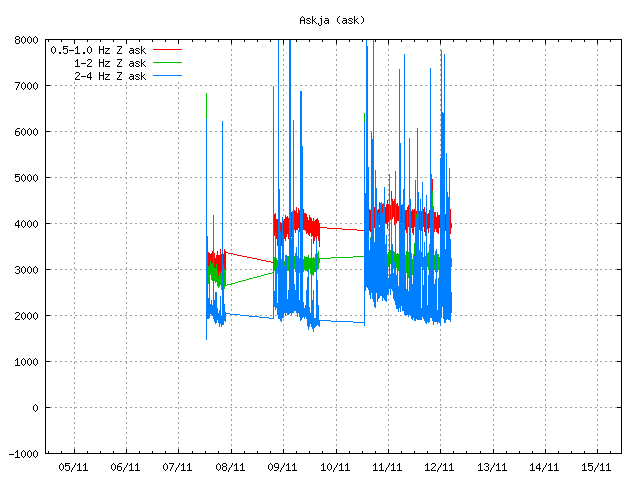
The current Askja plot suggests nothing other than normal movements of the crust (e.g. faulting). There is no indication of magma movement. However, I would stress that these plots alone do not provide definitive information on what is causing earthquakes, and one should be very wary of using these in any interpretation. Icelandic scientists have further data sources that they can use to better understand earthquakes and their origins, and that both supplement and corroborate the plots shown here.
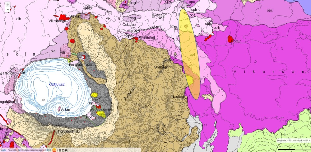
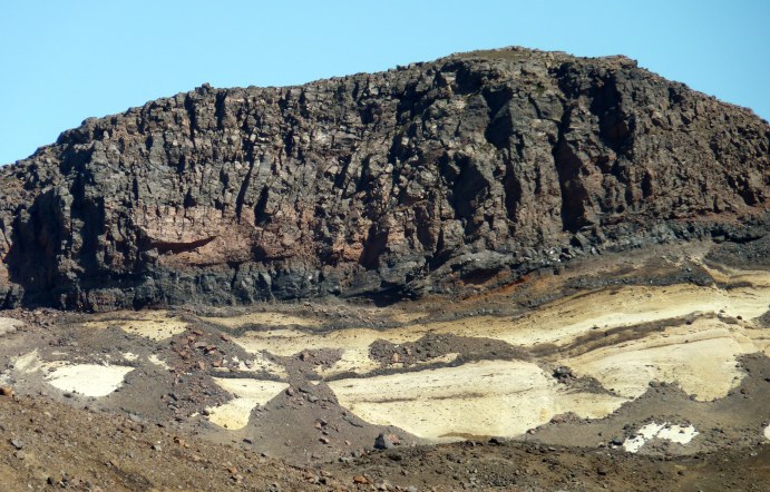
Finally, if you’re interested in the wider geological context, then there’s an online geological map of Iceland here and this allows you to zoom into a fair bit of detail, depending on which area you are looking at. (Some areas have been mapped in more detail than others.) The eastern side of Askja is shown in the map extract below, and I’ve added an ellipse showing roughly the area in which most of the earthquakes in the November 2019 have been occurring.
In another blog I’ll talk more about this earthquake swarm, and what might be causing it.
65.011054
-16.748528
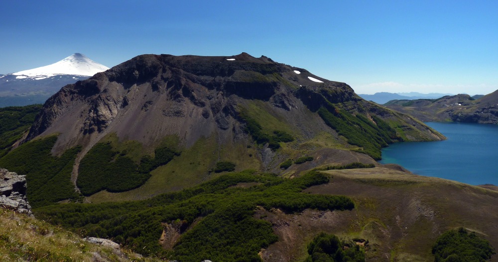
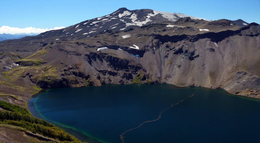
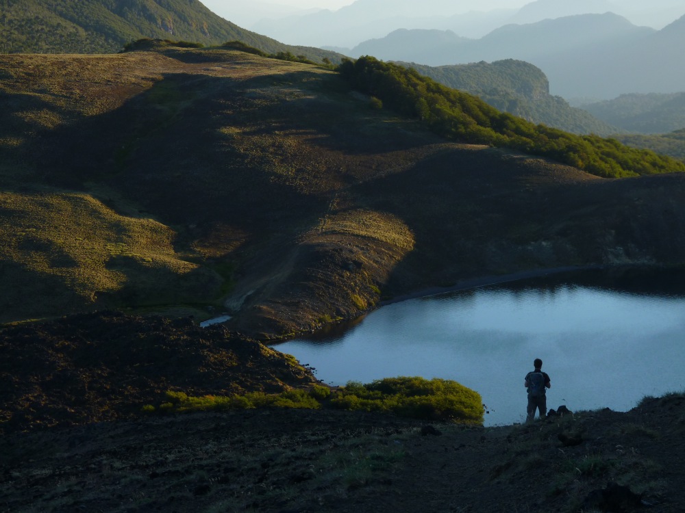
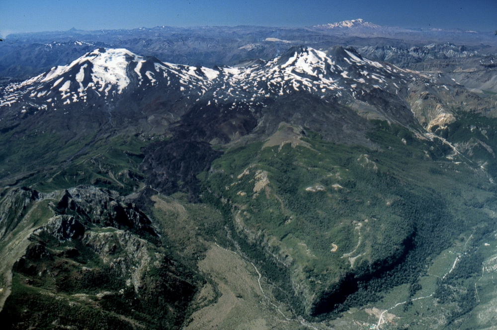
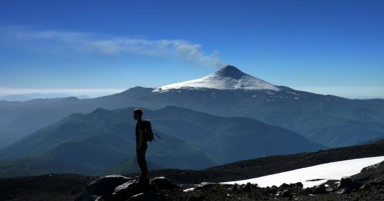
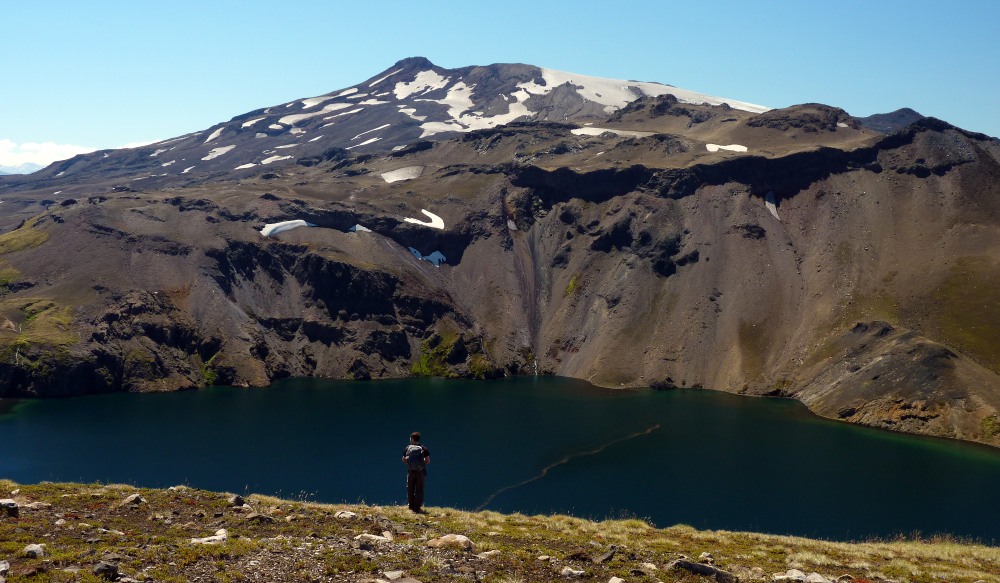
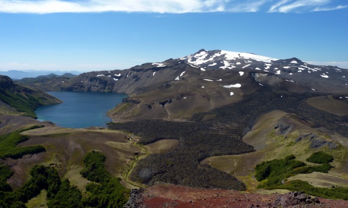
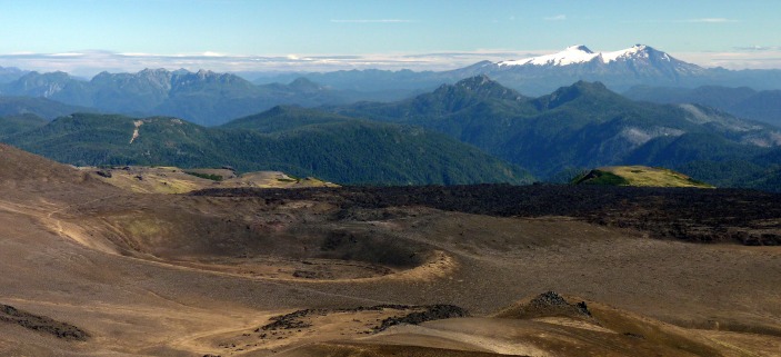
On 2 March 2015 I was camped at Laguna Azul, in the shadow of Volcán Quetrupillán, the volcano that I was working on. With me was Jonathan Moles, a PhD student who was working with me on Tindfjallajökull volcano in Iceland. I know, it’s a long way from Tindfjallajökull….
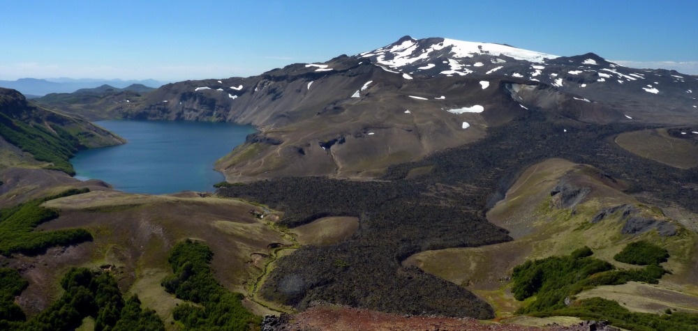
The lake of Laguna Azul with the ‘beheaded’ stratocone of Volcán Quetrupillán with its summit icefields. A young (Holocene) lava is prominent. A trachyte, if you’re interested in compositions. Our campsite is in a small wood on the far left of the image
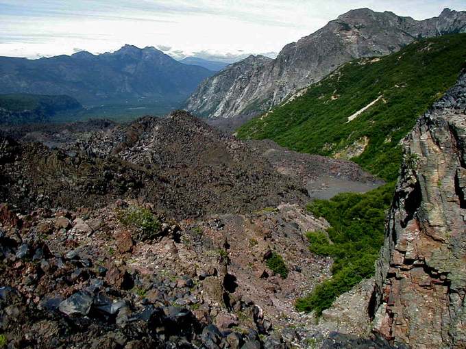
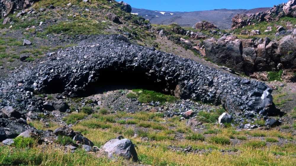
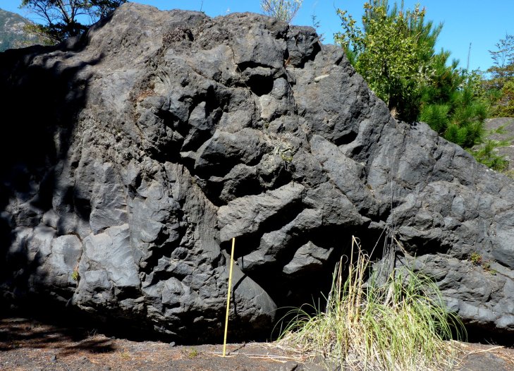
During 2 March we were working on some of the most spectacular columns you’ll ever see, where a subglacial trachyte fissure eruption along a pre-existing ridge had sent a lava stream into an ice tunnel, where it ponded and inflated, then cooled slowly.
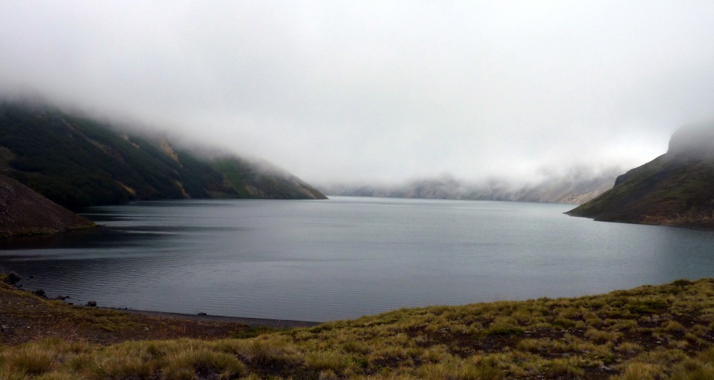
The morning of 2 March, with low clouds, moisture in the air, decreased visibility, and cooler.
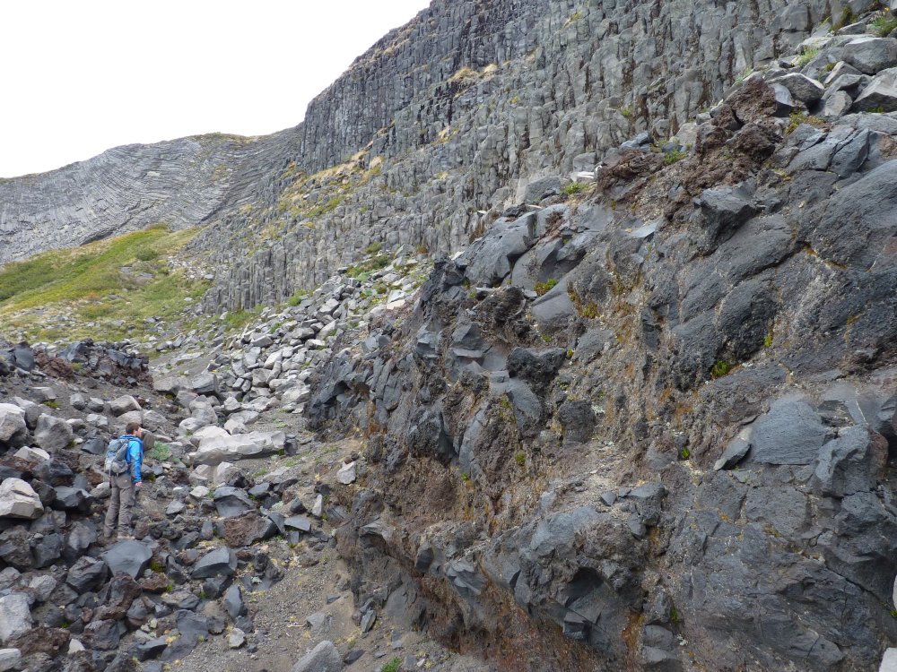
The target for 2 March. Spectacular columns in a ponded and inflated subglacial lava body. With younger (Holocene) lava margins smeared against them. Levees for the technical.
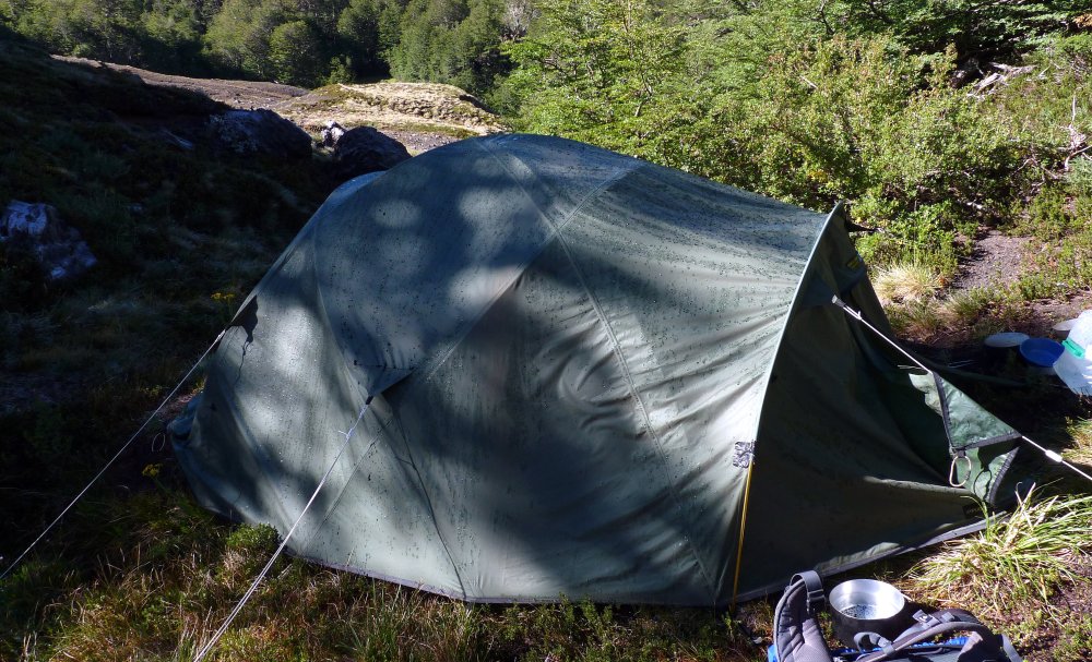
There was rain in the air on 2 March, and after the evening meal I wrapped up the hammock I usually sleep in when working in Chile (where there are trees, of course), and moved my sleeping bag into the tent Jonathan was using. It rained heavily that night, but through the tent the morning seemed bright and dry, so out I got out to get washed and get the stove fired up for our porridge and my coffee.
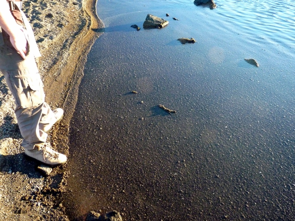
I keep soap beside the stream (I always use tea-tree soap in the field by the way), and when I picked up the soap, I spotted dark spots on it. Immediate thought was that the rain was so hard that it had splashed mud onto the soap. Then it clicked – the shapes and bubbly textures were wrong – these were lapilli. Turning around I saw that the tent was covered in ash and lapilli (I’ll call it tephra from now on, a good generic term), and looking around I saw the leaves and flowers covered in tephra. It could only mean one thing – a volcano nearby had erupted during the night, and the smart money was on Villarrica, as it had been having sporadic small summit explosions for many weeks.
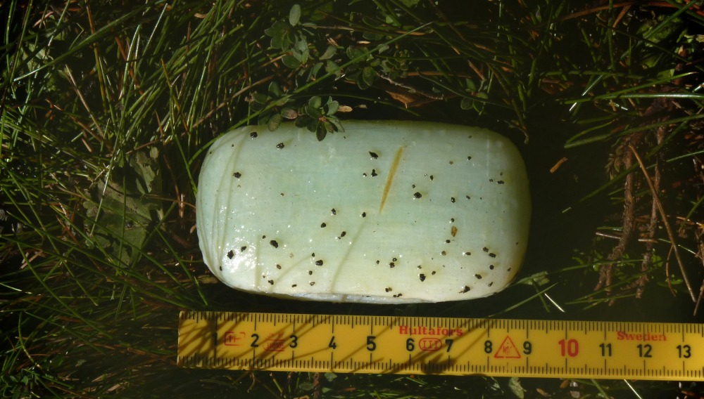
“Waiter, what’s this ash doing on my soap?”
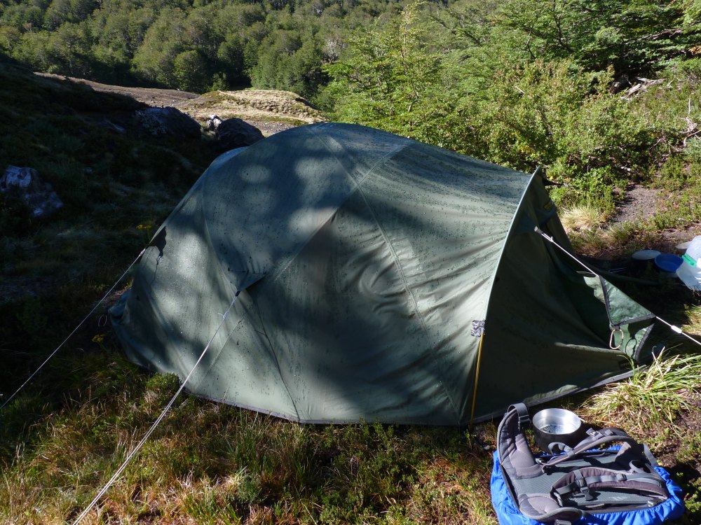
Tephra on the tent.
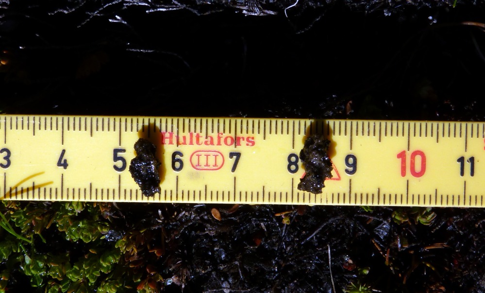
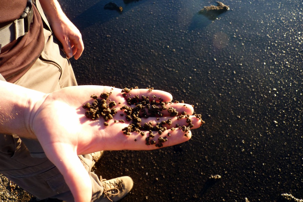
The two largest clasts that were on the tent.
Trouble was, there was a mountain ridge between us and Villarrica, so we’d have to get to the top to see if it really was Villarrica that had erupted and not another volcano such as Llaima or Lanín. So, the planned field objectives for that day were ditched in favour of climbing the ridge and having a week look to see if Villarrica had erupted. And it was Llaima or Lanín or Mocho-Choshuenco instead, then we’d be able to see them also.
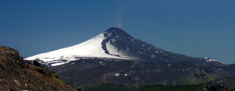
Villarrica on 1 March, before the 3 March 2015 eruption.
Mochu-Choshuenco – a lovely volcano with two distinct summits.
Lanín – sits in a chain of three with Villarrica at one end and Quetrupillán in the middle.
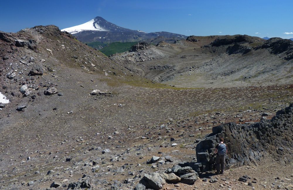
The mountain ridge above the campsite flanks the western side of the beautiful lake of Laguna Azul, and is a distracting beast to ascend for a volcanologist as it is the remnant of an older piece of crust of unknown age that contains ignimbrites and lavas, down which younger lavas (probably from one of the last three glacial periods) have flowed in ice tunnels to leave distinctive columnar jointed remnants. They tell of a time when the valley currently occupied by Laguna Azul was filled with ice, and in fact two of the lava streams that flowed in tunnels melted into the ice formed the dams between which Laguna Azul grew. But that’s another story….
Ascending to the summit of the ridge is not simple, and involves one slightly tricky move from a small gully onto an exposed rock face, shuffling a few steps across this, and then into a wider gully where it was a clear ascent to the top.
On getting to the summit of the ridge it was immediately apparent that it was Villarrica that had erupted. The beautiful snow-white summit cone was partly covered in dark tephra, and channels within this tephra told an interesting story of a slightly complex eruption involving some melting of the summit ice/snow.
Naturally, we took many pictures of Villarrica….
And now to what, for me, was a phenomenon that I’d never seen before – and that I haven’t seen since. Looking down onto Laguna Azul there was a gentle wind blowing along it, coming from the north, and part-way down the lake there was a distinct line, which binocular examination suggested was a raft of tephra. Even though Villarrica erupts a magma composition that is at the denser end of the spectrum, the high volatile (gas) content does mean that Villarrica’s tephra can be very ‘frothy’ and thus it can float. And the gentle zephyrs were pushing the floating tephra as a raft down to the southern end of Laguna Azul, where we encountered it later.
Although it’s a nice distraction having a recently-erupted and still steaming volcano to look at, there was work to be done and so we continued exploring and discovering the various delights of the fissure eruption that had formed Laguna Azul. Rather fortuitously, this eruption had left its feeder dyke exposed in places, which allowed us to gain some interesting insights into what actually happened during this subglacial eruption (of trachyte into ice). But that’s another story….
Everywhere we could see clear evidence of the tephra blanket produced when Villarrica erupted, with the once white and now dirty summit icefields of our own volcano (Quetrupillán) being very apparent. As we moved northwards the tephra grains become a bit larger, suggesting that we were moving towards what volcanologists call the ‘axis of dispersal’. It’s just a fancy way of saying that this is the direction that the eruption cloud was moving as it was driven by the prevailing wind at the time – so along this axis you’ll find the thickest deposits for a particular grain size.
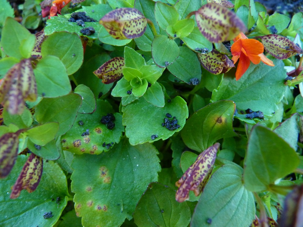
The flowers and plants had caught tephra grains, which were interesting both to see and to photograph. Especially as these were ephemeral features that with the first decent breeze or rain would disappear. It was a genuine privilege to be seeing some of nature’s newest features, and knowing that these would soon be gone.
When we got towards the south side of Laguna Azul, near where we were camped, we could see part of the raft of tephra by the shoreline, and could see quite a range in clast sizes. Downstream of the outlet there was a pond below a waterfall, and in this pond a raft of floating Villarrica tephra could also be seen.
Then it was back across the columnar jointed lavas that formed the southern dam of Laguna Azul, cooking and eating the evening meal whilst enjoying yet another beautiful Andean sunset. And then watching the Moon rise. Ah, fieldwork….
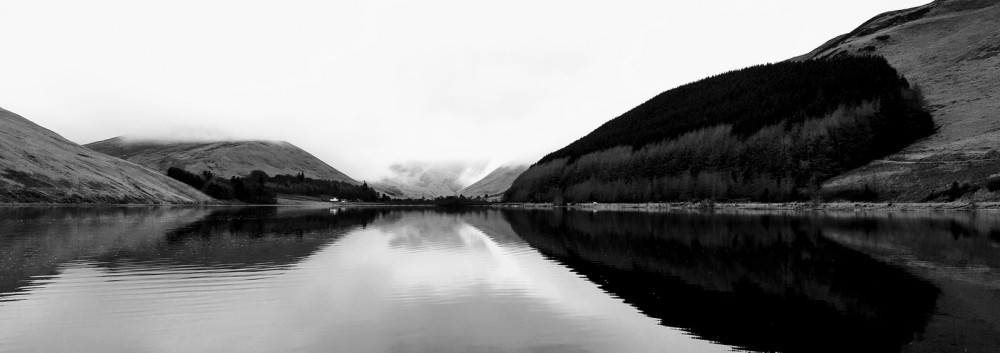
Loch of the Lowes on a calm February day. Image courtesy of Dan McGarvie.
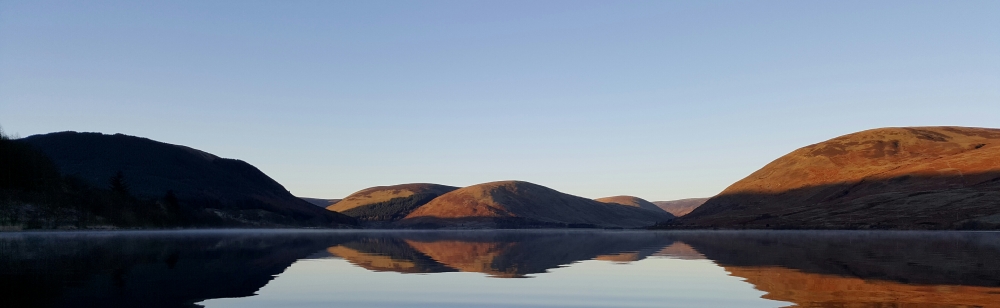
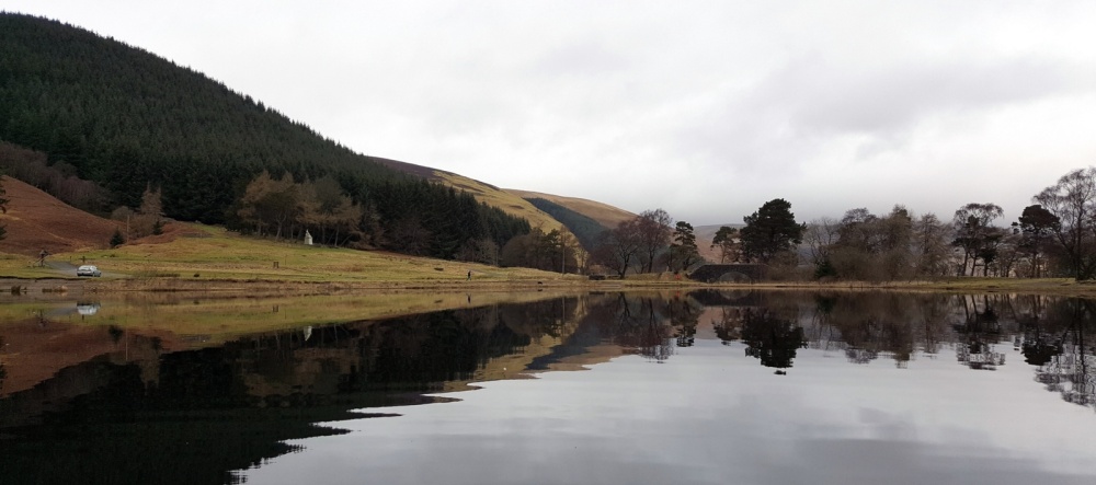
On St Mary’s Loch on a cold but calm December day.
Introduction
This blog shows the fun I’ve had wandering across these two lochs in the Scottish Borders in an inflatable kayak using a portable sonar. So far, I have completed the underwater contours (isobaths for pedants) on the smaller Loch of the Lowes, so I will provide this map first – in its entirely and also in sections that provide more detail. I shall leave the angler to use these maps as they see fit when deciding on suitable places to fish.
Panorama of Loch of the Lowes. January. Image courtesy of Dan McGarvie.
Images
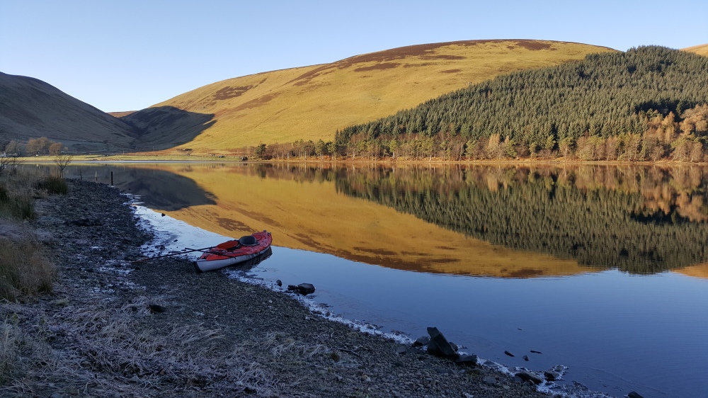
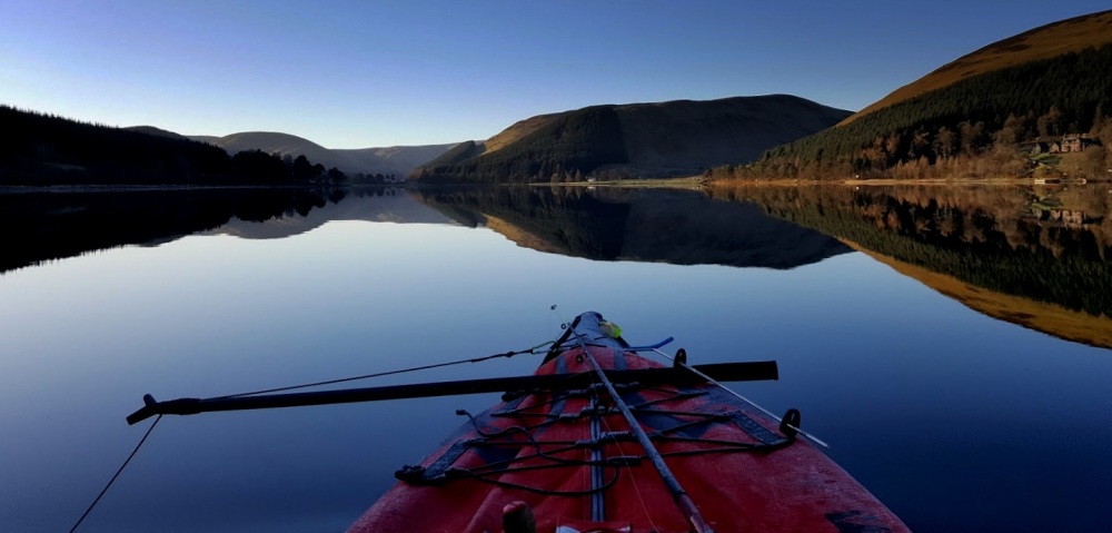
But first some images, because being out in a kayak on the lochs can be a rather special experience, with the interesting perspective one gets from being on a water-dominated environment. The rare days of calm conditions are especially enjoyable, as the reflections of the surrounding hills are mighty fine, to say the least. And when the only disturbance on the water comes from the ripples generated by the moving kayak, which leaves trails of foam defining the wake. The coldest I’ve been out was -5 Centigrade, but as it was calm the cold was not uncomfortable, and one could watch the splashes freeze on the paddle and on the kayak deck. The captions say a little more.
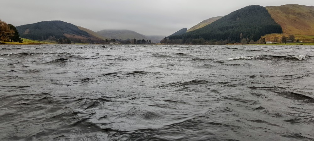
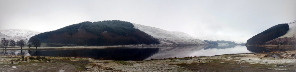
St Mary’s Loch in more typical conditions. December.
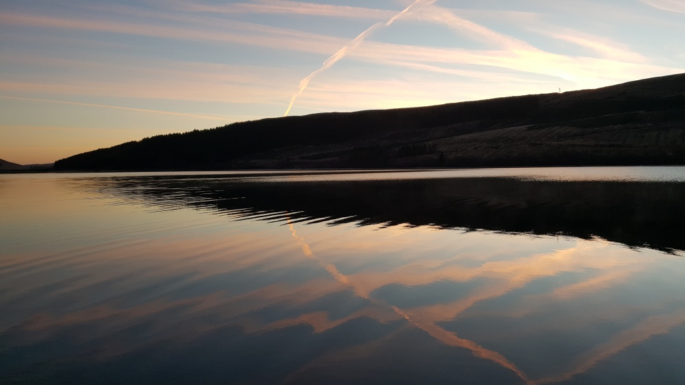
Just before sunrise at St Mary’s Loch. Temperature -5 Centigrade. December.
Stretching the legs, east bank of St Mary’s Loch. Dceember.
The Maps
Technical comments on the sonar and the maps are at the end, but here’s what’s useful to know when viewing (and interpreting) the maps:
- The underwater contours are at 3 foot intervals. The sonar provides readings at greater resolution than this (e.g. 9.4 feet).
- The sonar is less accurate at depths less than 4 feet.
- The colours range from shallow (dark orange) to deep (blue).
- The colour-depth range of interest to many Pike anglers using deadbait is c.15-30 feet, which is yellow (15 feet) through to pale green (30 feet) on the chart below, which shows depth-colour isobaths down to 60 feet.
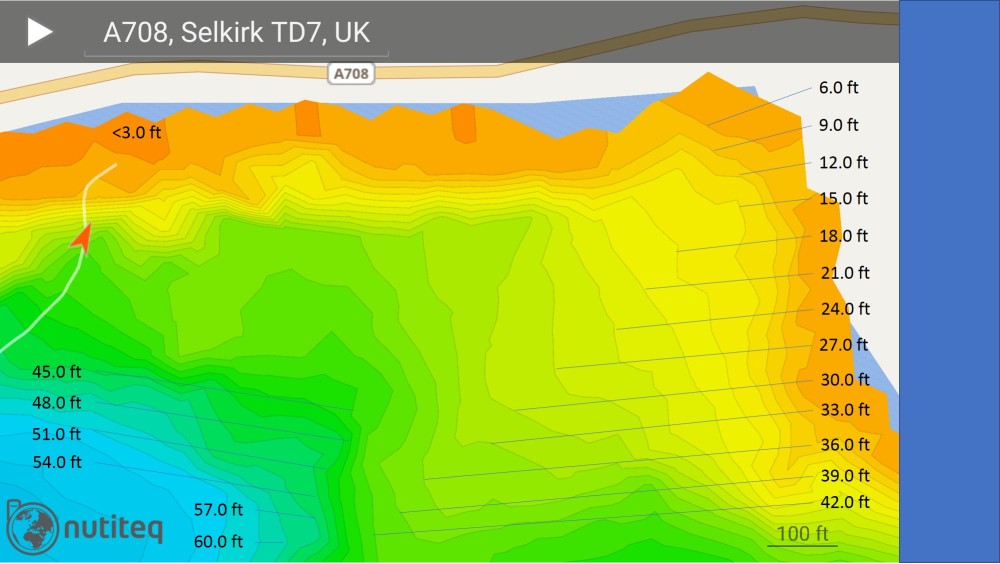
Loch of the Lowes new underwater (bathymetric) map
For interest, the original bathymetric map from the 1897-1909 Scottish survey is shown first, followed by the new map. It’s interesting to compare them, and one has to be impressed at the accuracy of the original surveyors who used weighted lines to determine water depths. The maximum depths recorded on both the old and new surveys match up beautifully.
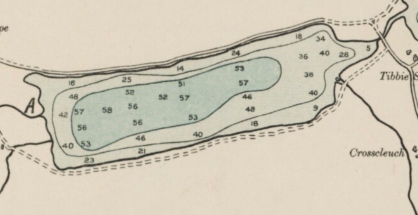
Loch of the Lowes original bathymetric map produced during the 1897-1909 survey (above), and the new map produced using the Deeper sonar (below). They match well, though the new survey understandably has greater detail.
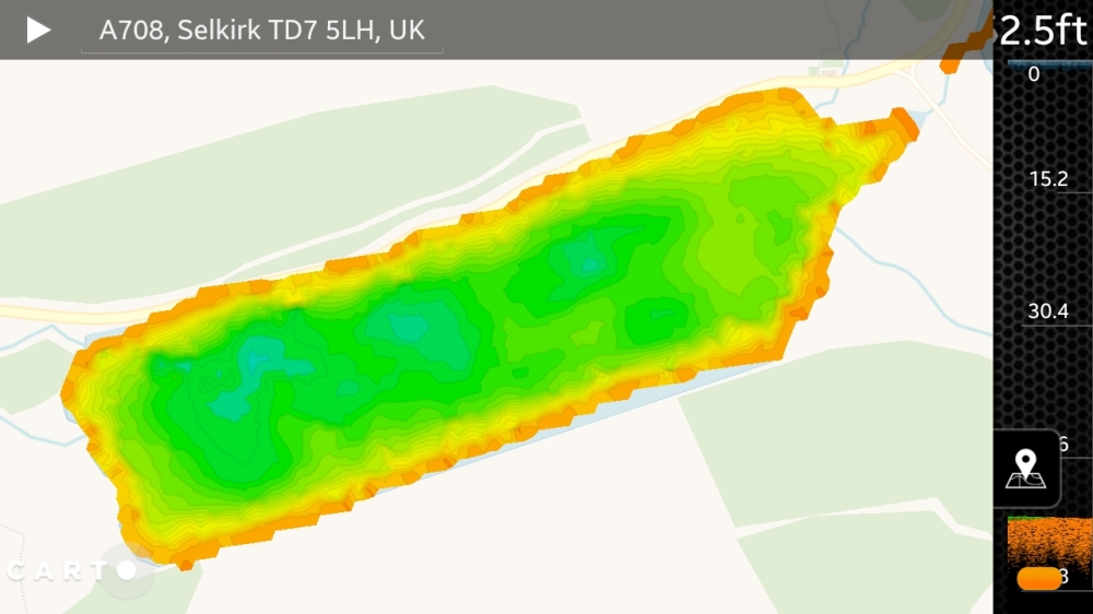
The new map (above) and is basically a screenshot from the app used with the sonar. When I have time I’ll try and learn how to extract the SQL files from the smartphone and import them into a GIS system such as QGIS to produce larger and better maps.
The Kayak and Sonar
I use an inflatable kayak, as it’s very straightforward to put it in the boot of a normal-sized car, get it out, carry it to the water’s edge, and then pump it up. I also have a trolley to enable me to inflate the kayak beside the car then wheel it down to the water. It takes about 15-20 minutes to get set up, and the same time to deflate the kayak and pack it away. The inflatable kayak I have is a beauty, made by Advanced Elements. Mine converts from a double to a single with ease, and paddling speed is just a bit less than a rigid kayak, with the added advantage that it’s so much more difficult to capsize an inflatable kayak. If you’re interested, it’s called the Convertible.
The sonar is a lightweight ball that houses the sonar, a sensor determining water temperature, and a wireless transmitter. The sonar sends pulses of data via wireless to the smartphone, on which live data is shown on a screen – water depth, type of bottom (weedy or rocky etc), and there’s also an option to switch on ‘fish icons’ which will show you individual fish and their depths, as well as a separate icon for shoals of fish.
On your smartphone you download the app and also a copy of the map of the country your body water is in. Your phone locates where you are using its built-in GPS.
Put simply, your smartphone screen shows where you are, and the wireless transmitter from the sonar shows the water depth and temperature of your position. The neat bit is that the track you take across the water is mapped in front of your eyes as you paddle along. By joining up a number of tracks you create the map.
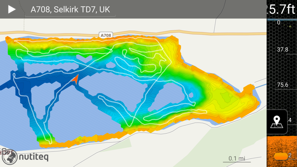
Example of compiling a map by connecting together different paths. Northern end of St Mary’s Loch.
The potential attraction of this to anglers is that a map can be ‘shared’ provided they have a smartphone and load the app. You phone’s GPS will locate where you are on the map, and so (for example) you can stand on the bank and know that 120 feet out there’s a drop-off from 20 to 40 feet. This is because you can tap the map on your phone and at the point at which you tap the water depth will be given. I’ll write a separate blog entry about how to do this and how to access the map data I’ve produced.
For now I’ll leave you with a few images of the kayak and sonar in action.
The sonar is attached to the end of (yes) a landing net pole so that the sonar is in reasonably calm water and does not impede paddling.
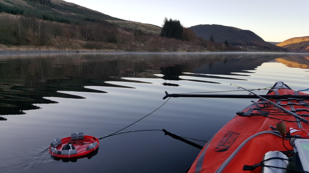
My bespoke sonar housing is cheaper and better than the ‘official’ sonar arm one can buy. It’s basically a frisbee with a hole cut into it, and with some foam pipe lagging for buoyancy. And yes, I occasionally stop and have a few casts.
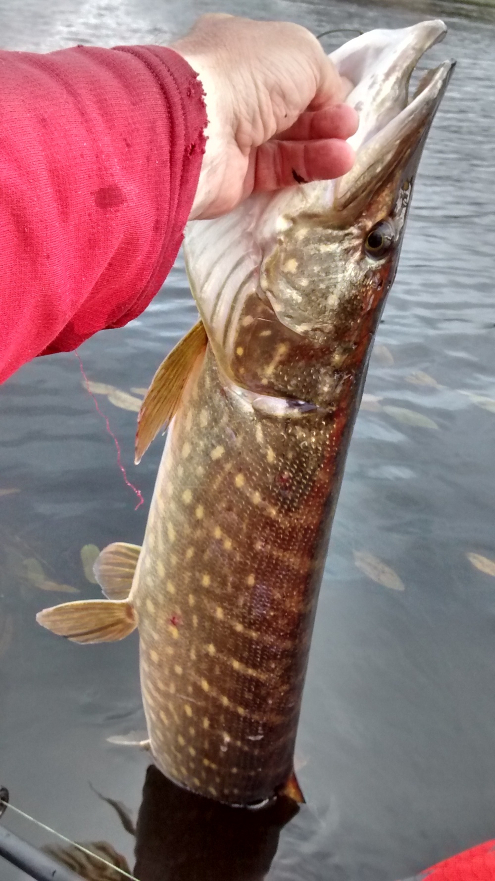
I find that even in the depths of winter Pike can be tempted to attack lures (I use various small softbait jigs). Unhooking from a kayak is straightforward as one is so close to the water, with the added advantage (to the Pike) that a proportion of the Pike’s body can stay in the water (for support), except when taking a pic as above. I never weigh them, as I like to return them swiftly because they don’t have much energy in winter. But if it was a really big one…?
Top end of Loch of the Lowes. The statue of James Hogg can be seen left of centre.
55.492975
-3.189521
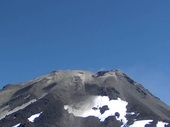
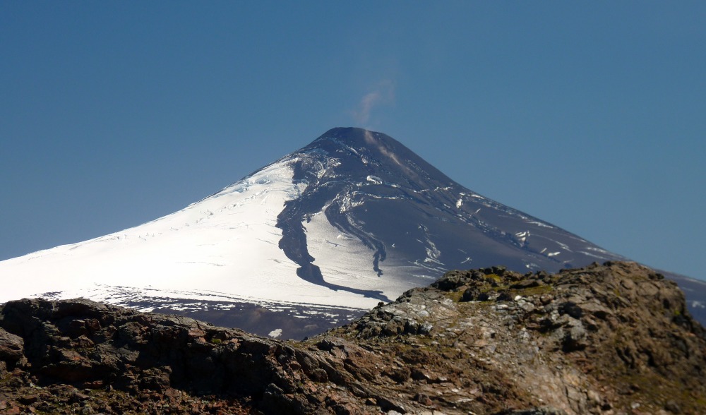
This is the highest part of Nevados de Chillan – the aptly named Cerro Blanco, with a young (Holocene) basaltic andesite lava flow in the foreground. Cerro Blanco lies in the NE part of the volcanic complex, whereas the part of the volcanic complex that is showing signs of unrest is at the SE end, in the Las Termas area. In this blog post I’ll discuss the types of eruptions that might happen in the near future. Then I’ll provide some background on the Nevados de Chillan volcanic complex itself. I’ll finish off with some examples of lava-ice interactions at Nevados de Chillan.
Nevados de Chillan volcano in southern Chile has been showing signs of unrest since September 2015, and this is likely to lead to an eruption within the next few weeks-months. On 8 January a new vent was observed, and there are now 3 webcams focused on the volcano as well as a host of instruments measuring the developing unrest. See this link. So if an eruption does occur and the visibility is good, you’ll get a ring-side seat courtesy of the Chilean geologists and authorities.
Webcam capture on 30 January 2016 at 20:00 GMT from Portezuelo webcam. See hyperlink above.
What makes me think that this unrest is likely to lead to an eruption? Well there are two main reasons.
Firstly, there’s clearly been a new heat source introduced into the plumbing system beneath the volcano, and this has drilled a new pathway to the surface leading to bursts of heat escaping through a new vent. This heat source is almost certainly due to magma rising up in the plumbing system. And at the moment there’s a ‘vent-clearing’ phase in place, with bursts of heat interacting with water contained within the cone (hydrothermal). There are probably magmatic gases involved as well. These energetic outbursts are clearing out material in the developing conduit, and possibly also pulverising (fragmenting) material being blown out.
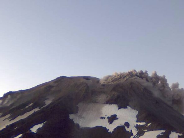
Webcam capture at 09:53 GMT on 30 January 2016 showing small and ground-hugging low plume of particulates.
Secondly, this new vent has developed on the youngest cone at this volcanic complex, which has developed through a long series of eruptions, punctuated by time gaps of a few years to decades.
The twin cones of Nuevo and Arrau, that form part of the Las Termas, a particularly active part of the volcanic complex and one that erupts evolved and viscous dacite/rhyolite magmas.
In essence, this is quite a simple situation. An eruption from the new vent would simply be just the latest stage in the development of Nevados de Chillan’s youngest cone.
So what sort of eruption might we expect?
To answer this we can look at recent eruptions, as well as the series of eruptions that constructed this part of Nevados de Chillan. And this is a key point – Nevados de Chillan is not a simple cone-shaped volcano like the current Mount Fuji – instead it comprises a number of volcanic centres aligned in a roughly NW-SE direction, along with older rocks and remnants of caldera walls that are considered to have formed when large ignimbrite eruptions took place. I’ll return later to some of the older rocks – especially those that show evidence of lava-ice interactions.
But back to recent eruptions. The most recent eruption was a small eruption that took place in 2003 after a gap of 17 years (1986), lasted about a week, and produced episodic and small pulses of ash ejection that rose up to 500 m above the cone See LINK
The new vent formed on the saddle between the two newest and overlapping cones in this part of the volcanic complex – Nuevo and Arrau. (See diagram below.) A small ~64 m double crater was formed, with measurements of the two craters being 25 x 14 m and 39 x 28 m.
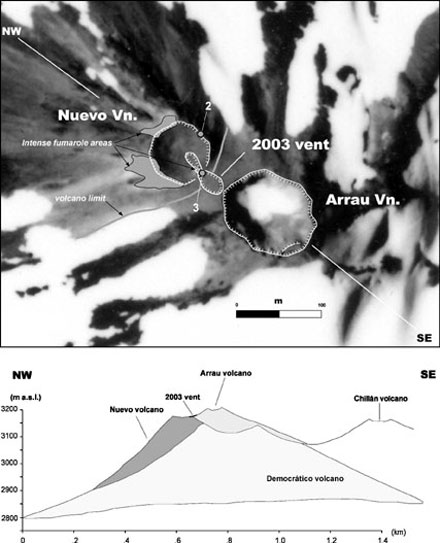
Nice diagram from Naranjo et al., (2004) – see link above. Shows the 2003 vent in relation to the young cones of Nuevo and Arrau. Also shows how the young cones have been build upon the older stratovolcano of Democratico.
A thin and restricted carpet of ash was produced, much of it on snowpack. An interesting point is that if this eruption had occurred a few centuries ago, it might not have been recorded as it was so small, plus the thin ejecta blanket (being on snow) would not have been preserved for study by present-day volcanologists. The point being made is that such small eruptions in the past on ice/snow-clad volcanoes relatively remote from local populations are unlikely to have been observed, plus as the deposits have very poor preservation potential (being emplaced on snowpack), there will be no record of such eruptions. One of the little challenges for volcanologists working on snow/ice-clad volcanoes.
Such a small eruption could indeed be what Nevados de Chillan is building up to produce. But speaking personally, I’d rather see an eruption of the kind that produced the two newest and overlapping cones in this part of the volcano. These are called Nuevo and Arrau, with Nuevo being formed in the period 1945-1945, and Arrau in the period 1973-1986. The small 2003 eruption was the first since Arrau stopped erupting in 1986.
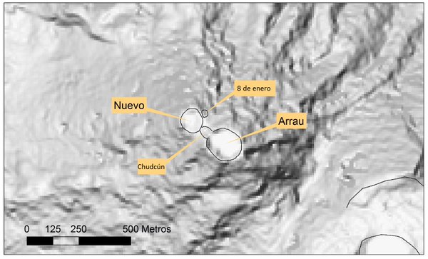
The Las Termas area in the SW of the Nevados de Chillan complex, showing the two young cones Nuevo and Arrau. The small 2003 vent (mentioned above) has been given the name Chudcún. The new vent that opened on 8 January is indicated. Source: LINK
These two newest cones have been built on top of (and largely obscure) an older stratovolcano (see figure above). These new cones are constructed of interesting rock types (dacite and rhyolite) that are extremely viscous and gas rich, and so eruptions tend to be explosive as gas escaping from the magma blasts apart the magma into ash and pumice. (It’s one of those counter-intuitive quirks of science that escaping gas is stronger that molten rock and can actually fragment it. This leads to the production of enormous eruption clouds composed of fragmented magma, such as the 30 km high eruption plume formed when Chaitén volcano unexpectedly erupted in 2008. But I digress….)
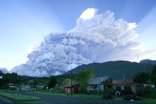
Chaiten volcano erupting in 2008. A classic example of the eruption of a massive amount of viscous and gas-rich rhyolite magma is a short time (i.e. high mass eruption rate). Source LINK
However, when these viscous magmas can rise to the surface without being completely blasted apart, then they will form slow-moving lava flows that combine to form steep-sided cones just like the Nuevo and Arrau cones at Nevados de Chillan. So this is what I’d like to see – a number of lava flows effusing from the new vent and building a new cone that, given the position of the new vent, might grow to be the highest point on this part of the volcano and exceed the heights of the Nuevo and Arrau cones.
Is such an eruption likely to be dangerous? What hazards are likely? The Chileans are aware of the potential hazards from their volcanoes, and of course those that are snow/ice-capped present an additional hazard if there is a great deal of melting, as the meltwater will move downhill into drainage systems, where it can entrain particulate matter and eventually develop into a lahar. However at the moment it is late summer in Chile and consequently snowpack is close to its minimum annual mass. Good news. Sernageomin has prepared hazard maps and will work with the local authorities to ensure that populations in danger are informed and if necessary evacuated http://www.sernageomin.cl/volcanes-mapas.php. After all, this is considered the 7th most active volcano in Chile, so it’s an obvious target for hazard planning and mitigation. See LINK
So, to sum up the current activity. This latest unrest could be a damp squib and we may see nothing more than the current puffs of particulate matter being ejected a few hundred metres above the new vent, rather like the tiny 2003 eruption. Or we may (more excitingly) see magma rise to the surface and effuse out of the new vent to produce steep blocky lava flows that slowly pour down the sides of the Nuevo-Arrau cones. The above two scenarios are the most likely ones based on the past activity that built the Nuevo and Arrau cones. I’d be surprised if there was a massive explosive eruption that produced a Plinian eruption column, but volcanologists always have in the back of their minds a number of ‘worst-case’ and ‘unlikely’ scenarios – just so they have done a bit of thinking about them on a just-in-case basis.
The volcanic complex
I’ve described Nevados de Chillan as volcano complex, and not a volcano. The reason for this is that unlike, for example, Villarrica which has a single prominent cone that is the focus for most eruptive activity, Nevados de Chillan has a number of recent vents/cones (estimated to number c.13) that are aligned NW-SE for c.10 km.
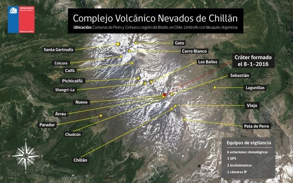
The Nevados de Chillan volcanic complex. Source: LINK
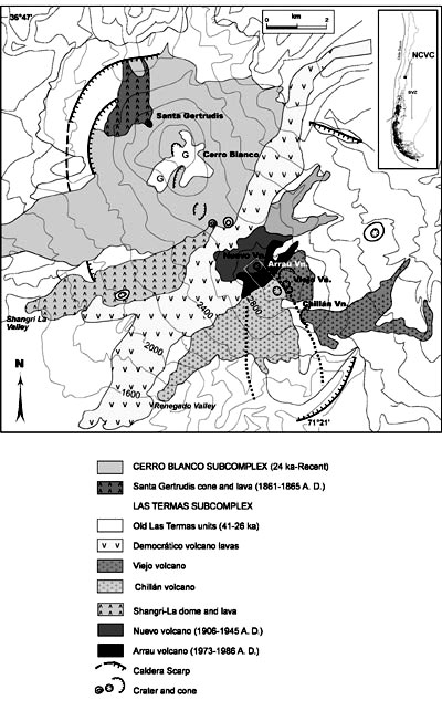
Geological map of Nevados de Chillan, from Dixon et al., (1999). LINK
There is evidence of an ancient volcanic complex that predates the newer c.10 km long volcanic complex, in which there are remnants of caldera walls. Some work has been done on these and can be found at LINK
This is a pattern that occurs at many Chilean volcanoes – an early volcano complex that produces caldera-forming eruptions (with associated ignimbrite sheets), and then a younger volcanic complex develops within the caldera(s). Another quirk that occurs fairly often at Chilean volcanic complexes is that two discrete centres of volcanic activity can develop, which erupt quite differing magmas. This is the case at Nevados de Chillan, where the NW volcanic centre (Cerro Blanco) erupts mostly magma around basaltic andesite in composition, whereas the SW centre (Las Termas, which encompasses the youthful Nuevo and Arrau cones) erupts the more evolved rock types of dacite and rhyolite. I’ll be honest with you, I’ve not yet read a thoroughly convincing model that fully explains why this happens.
The two main centres of the Nevados de Chillan volcanic complex that have been active in recent centuries. On the left (NW) is Cerro Blanco, and on the right (SE) is Las Termas where the Nuevo and Arrau cones are. This is where the January 2016 vent has appeared.
The prominent dark lava in the aerial image above is a relatively young dacite lava flow. This image shows what this lava flow looks like on the ground, with glassy dacite (foreground) plus piles of blocky rubble that characterise the surfaces and sides of these lava lobes. This is the sort of lava that might be expected to appear if there was an effusive eruption from the new vent that opened on 8 January 2016.
The most recent eruption from Cerro Blanco took place from 1861-1865 and produced a lovely basaltic andesite lava flow that melted a fair bit of snow and sent meltwater down into the Santa Gertrudis valley. Not always as a steady trickle, as a portion of the meltwater was dammed and escaped as a flood.
In the foreground is Cerro Blanco, with the 1861-1865 flank eruption of the basaltic andesite Santa Gertrudis lava with its source cone (both characteristically dark). The lava lobe on the lower left is plunging into the upper parts of the Santa Gertrudis valley.
As part of a wider study of lava-ice interactions at Nevados de Chillan I visited this lava flow in 2001 whilst I was supporting a PhD student based at Lancaster University (UK), and discovered a number of fractures indicative of enhanced cooling of lava, which implied water/snow/ice was involved. This was followed up the following year by the PhD student (Katy Mee) and a colleague (Hugh Tuffen) who did a more detailed study and wrote this up as a paper. See LINK
The 1861-1865 Santa Gertrudis lavas. Taken in 2001.
The wider study of lava-ice interactions at Nevados de Chillan along with a geochemical and geochronological study was published as a separate paper, which can be accessed at LINK or at LINK
Lava-ice interactions
One the aspects of research I am particularly interested in is what happens when lavas interact with ice and snow (or the cryosphere if you prefer a more grandiose name). What happens with sustained eruptions (point or fissure) under thick ice is arguable fairly straightforward with different volcanic rock types (lithofacies) produced in response to varying ice/water conditions, and enhanced complexity occurring as edifices collapse, vent positions shift, and intrusions permeate the edifice.
Anyhow, the point I am making is that unlike eruptions into thick ice sheets, lava-ice interactions at stratovolcanoes is a subject that has not been much studied, and yet these interactions produce a surprising diversity of landforms because of the varying thicknesses and properties of ice/snow, the type of lava erupted, how fast it is erupting/flowing, and topographic aspects such as slope angle and so on.
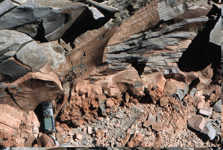
A small tongue of lava displaying characteristics that indicate it has been more rapidly cooled than just by interactions with air. It has a glassy texture (indicating rapid cooling) and a set of closely-spaced fractures – the latter are produced when heat is rapidly extracted from a lava, and water/ice is very effective at doing this. Air is not.
At Nevados de Chillan as well as good examples of lava-snow/ice interactions during the 1861-1865 eruption of Santa Gertrudis lavas, there are older examples and I’ll deal with a few of these. I’ll say now that the images (taken in 2001) are a combination of early digital camera (175 kb max) and slide scans from a rusty old scanner, so don’t expect crisp and sharp images.
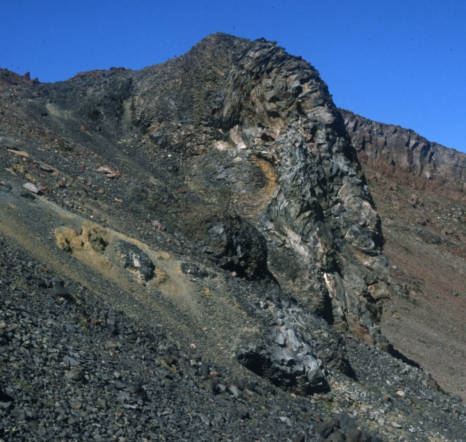
A tongue of lava that has a vague similarity to an Elephant’s trunk. Structures within the lava (e.g. flow bands and folds) indicate that it started at the high point and then propagated downwards. Pale yellow material consists of quench fragmented lava. The interpretation is that a lava was ‘perched’ on the flanks of an ice stream, and then decided to exploit a meltwater tunnel in the ice, which it enlarged as it melted its way downwards. With difficulty.
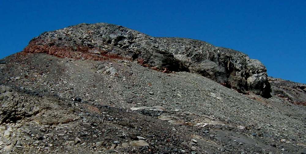
Lava lobe that encountered ice. This has a confined shape, consists of glassy and fractured lava, and in this case has a reddish (oxidised) base. The ‘Elephant Trunk’ lobe above came from another exposure of this lava, just out of shot to the right.
Reddish base of the lava lobe shown in the previous image. This shows intense fracturing (hackly fractures for the pedants), above which a zone of platey fracturing develops. Above this occurs microcrystalline to glassy lava. The degree of fracturing is much greater than is seen in a typical subserial flow (i.e. erupted in the absence of water/ice/snow), and so it is interpreted that ice/snow was present at the time of eruption. The ‘confined’ morphology of the lava lobe along with its glassy and fractured carapace helps to corroborate this interpretation.
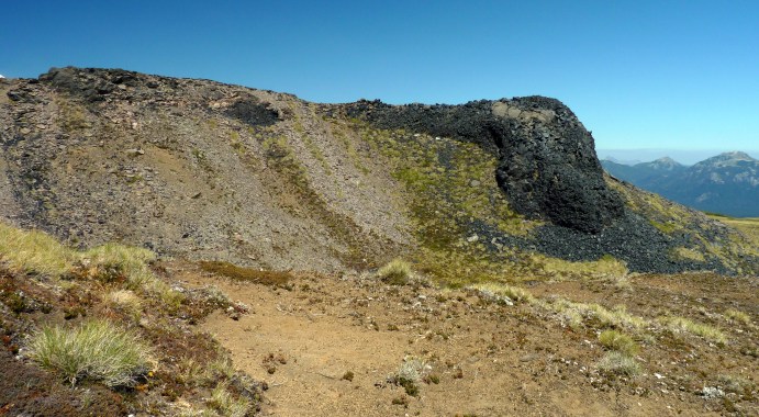
The prominent scarp in the foreground has been interpreted as a caldera fault, and it curves round (to the right) to pass in front of the highest peak (above the pool).
Endnote
This has been a bit of a long and rambling blog entry, but as it’s such a contrast to the limitations of writing a scientific paper I have perhaps gone a bit over-the-top. Well done if you get this far! All good wishes, Dave.
This short blog entry is rich on images and short on text. Its purpose is two-fold. First – to provide a brief introduction to the recent (Holocene) volcanism of this poorly-understood volcano, and second – to provide a bit more information for candidates interested in applying for the currently-advertised PhD project at the University of Edinburgh on this very topic, on which I am a supervisor.
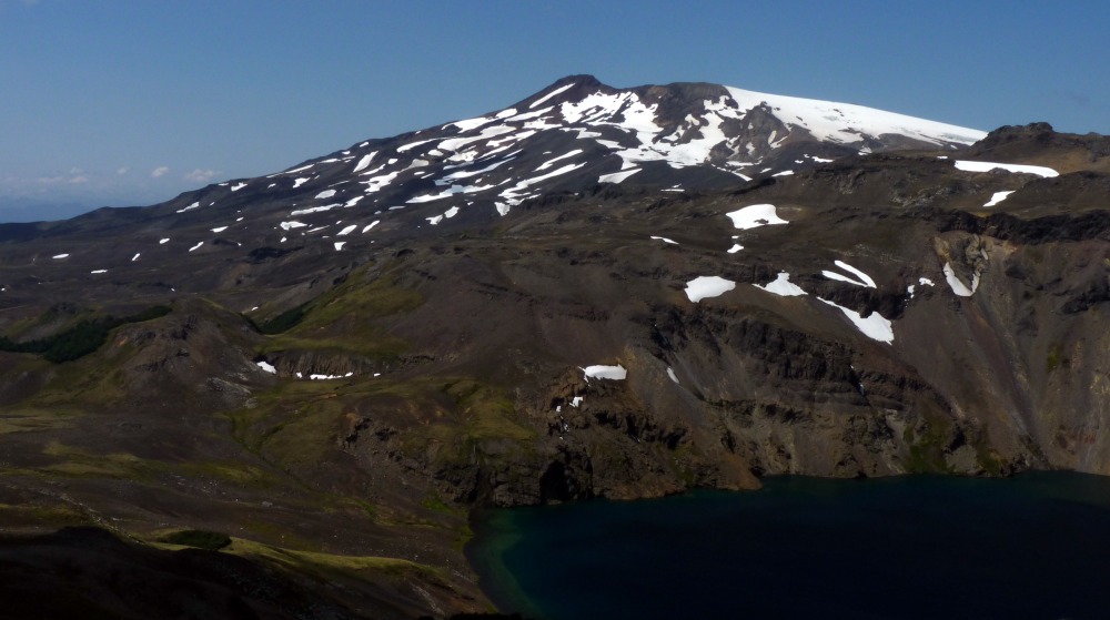
The ‘beheaded’ Quetrupillan stratocone from the SW, with Laguna Azul in the foreground. The sheets and lobes on the ridge in front of the main stratocone are formed from a subglacial (Pleistocene) dacite eruption of unknown age.
So why is so little known about Quetrupillán? One key reason is that with one of Chile’s most active volcanoes (Villarrica) being such a close neighbour and with Villarrica’s past reputation for causing death and disruption, a nearby volcano that hasn’t erupted within living memory and has no obvious signs of current/recent unrest, won’t be given much if any attention. And that’s fair enough, because when you have finite resources to monitor potentially dangerous volcanoes, you need to focus those resources wisely. Even knowing what I now know about Quetrupillán, with limited resources I’d still put my monitoring equipment onto volcanoes such as Villarrica, Llaima, Calbuco, Puyehue-Cordon Caulle, and so on.
Quick big-picture context. Running through this part of Chile is a c.1200 km long approximately N-S fault zone called the Liquiñe-Ofqui fault zone LOFZ, along which many of the volcanic centres of Chile are associated. Quetrupillán lies in the middle of a NW-SE chain of three volcanoes that cuts obliquely across this fault zone, with Villarrica at the NW end and Lanín at the SE end.
I’m only mentioning this because one of the key features that distinguishes Quetrupillán from its two neighbours in the chain is that it sits astride part of the LOFZ, and on closer examination it is clear that many volcanic vents to the south and around the east and west flanks are aligned along roughly N-S fissures. This has given Quetrupillán a rather mixed morphology, with focused vent activity producing a ‘beheaded’ stratocone developed to the north, and more dispersed fissure-controlled activity producing a fascinating volcanic field to the south with abundant evidence of (Pleistocene) volcano-ice interactions as well as recent (i.e. Holocene) explosive and effusive eruptions.
I’m currently writing a paper on the volcano-ice interactions that have taken place during the Pleistocene, and I’ll write another blog entry when this is close to publication with more images than a journal will allow. Previous blog enties contain some information: Blog 1 and Blog 2
There’s also evidence of lateral transport of pyroclastic material in surrounding valleys (i.e. pyroclastic flows – or pyroclastic density currents for the pedants), as well as pyroclastic deposits formed via sedimentation from volcanic plumes. What we call ‘fall’ deposits which are important as they represent the remnants of sizeable eruption plumes in the past.
So enough of the text and onto the images.
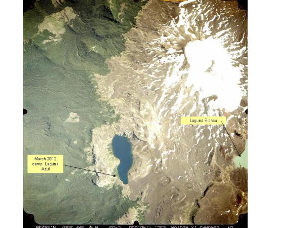
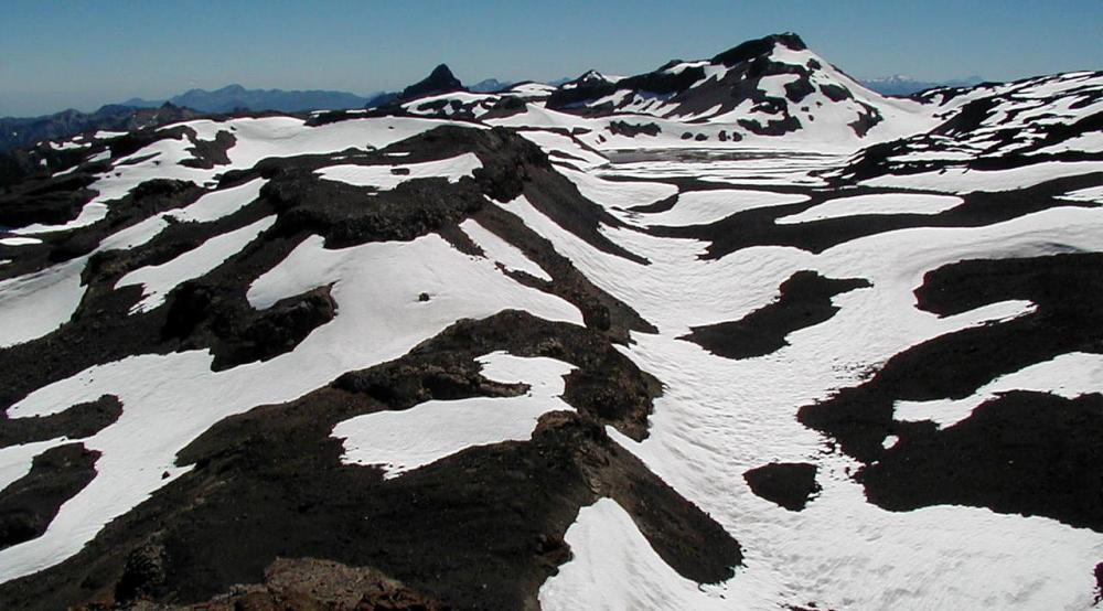
Western side of Quetrupillan (north to top) showing the beheaded stratocone to the north with ice-filled summit crater, along with two key geographic features – Laguna Azul and Laguna Blanca.
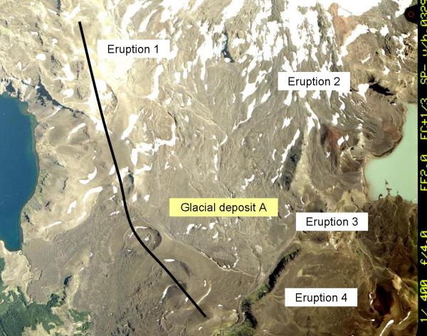
Eruption 1 is a dog-leg fissure eruption (probably dacite), which in the south has been highly productive in producing lavas. In the north it has mainly resulted in initial vent clearing with the formation of craters that have cut into pre-existing Pleistocene deposits. Eruption 2 comprises part-eroded lavas that are more likely to be early than late Holocene. Eruption 3 is a thin lava flow (basaltic andesite?) that is partly covered by aeolian deposits and the rising waters of Laguna Blanca. Eruption 4 is a small lava flow than has not travelled far from its vent (hidden) to the SE.
Read the rest of this entry »
Summary
I had a delightful month in Chile earlier this year (February-March 2015) with the main focus being a two week expedition to Volcán Quetrupillán to continue my project on volcano-ice interactions.
Whilst at Quetrupillán our nearest volcanic neighbour (Villarrica) erupted and showered the tent and landscape in ash. And for the final few days of my trip I helped US colleagues do a recce of Volcán Llaima as they wanted my help to look for examples of lava-ice and lava-water interactions (two of my research specialisms).
Villarrica (left) after the 3 March 2015 eruption and Quetrupillán (right) with a dusting of ash from the eruption. Lake is Laguna Blanca.
Villarrica
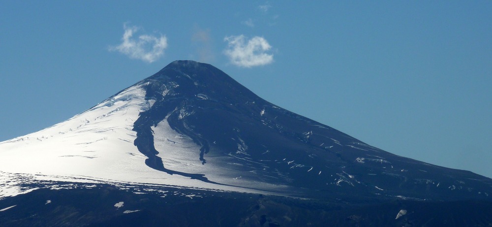
So let’s deal with the excitement of Villarrica’s big eruption first! Prior to the big eruption there had been a number of small eruptions – a bit of throat clearing as well as small amounts of new magma exploding. I saw a few of these – see below.
Small eruption from Villarrica volcano, a few days prior to the major eruption of 3 March 2015. Male model is Jonathan Moles, PhD student at The Open University.
Villarrica had its big eruption early in the morning of 3 March 2015, in clear and cloudless weather. http://www.bbc.co.uk/news/in-pictures-31726286 This meant that many people took great images and videos. Not us unfortunately. At our campsite c.25 km away we were in thick cloud and heavy rain, with a c.300 m high ridge between us and Villarrica. We awoke to a bright and sunny morning, and immediately noted something was odd: there was ash on the soap, in the cooking pots, and on the tent, and when we brushed against the trees we had the rare experience of ‘ash showers’.
Villarrica ash on the tent on the morning of 4 March 2015.
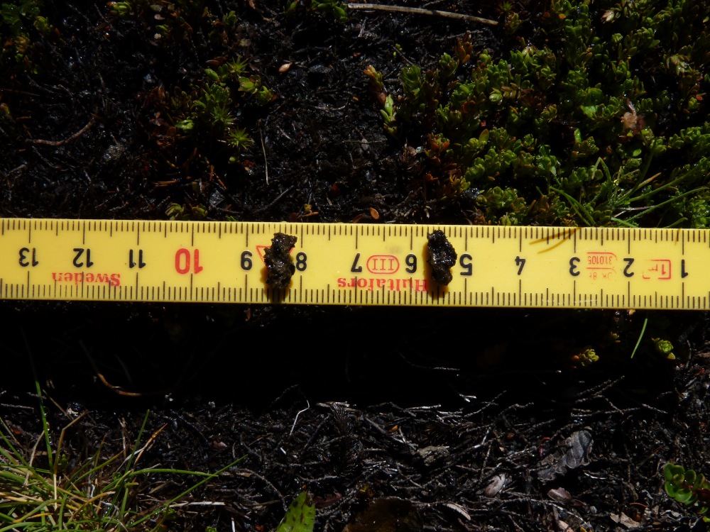
Two of the largest clasts from Villarrica’s 3 March eruption. Collected from the tent flysheet.
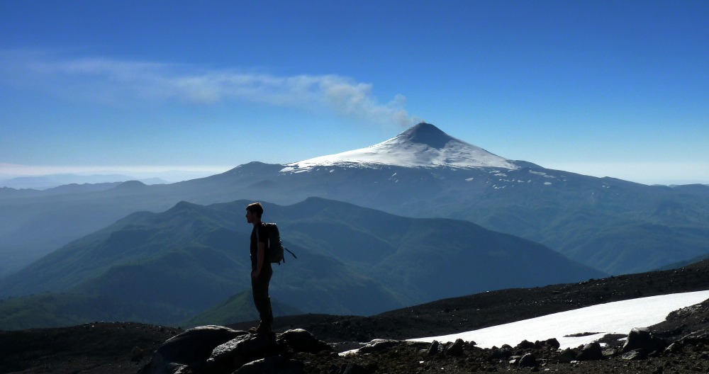
On examining the ash shards it was clear that it wasn’t just a big throat clearing event – this was an eruption of fresh and gas-rich magma. It had to be Villarrica! After a hasty breakfast we ascended the c.300 m high ridge to see what had happened. What a transformation – the summit cone was coated in thick black pyroclastic deposits, with clear evidence of material being mobilised and flowing down towards the base of the summit cone. The day on the ridge (4 March) as we travelled north the ash layer became thicker and the shards became bigger, so we were clearly walking towards the main axis of dispersal (i.e. the direction-line along which wind had blown the ash cloud).
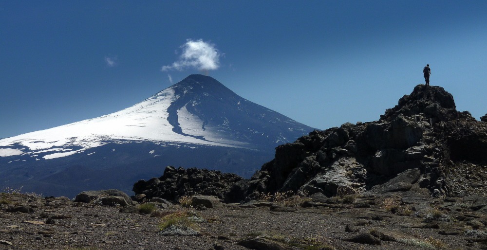
Villarrica on 4 March after the big eruption. From the ridge above and west of Laguna Azul, Quetrupillán.
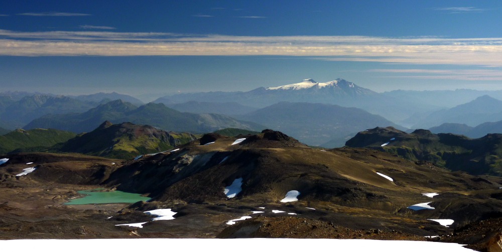
We saw the unusual sight of pumice floating in the lake below us (Laguna Azul), and saw that the summit ice cap of Quetrupillán was dusted in ash. A dusting of ash is known to increase ice melting rates, so the Quetrupillán ice cap may melt at a higher rate until the next big snowfall covers the new ash.
Pumice raft from the 3 March eruption of Villarrica floating in Laguna Azul. Ash-covered Quetrupillán summit in background.
We still had no idea how big the eruption was, and we only found out how serious it had been when we got back to civilisation and hearing that over 3,000 people had been evacuated from the town of Pucón. So we were there, but we missed the big one.
Quetrupillán
Although Quetrupillán has the potential to produce decent eruptions that could affect nearby towns and communities – and there is evidence of such eruptions in the past few thousand years – what most interests me is that Quetrupillán has an unusual number of well-preserved examples of volcano-ice interactions. In 2014 I had a couple of weeks discovering and working on some, and the aim of 2015 trip was to discover new examples and do some detailed sampling and work on selected examples. So the images below and their captions describe some of the examples of volcano-ice interactions that exist at Quetrupillán.
One of the chief aims of this work is to provide insight into the longer timescale over which a volcano has been growing and erupting.
Basically, for volcanic systems that have been active for hundreds of thousands of years, the past 9-12 thousand years is a mere snapshot and is unlikely to be representative. Having a longer timescale to play with allows insight into cycles of behaviour and activity (e.g. surges of fresh material rising into the volcano over centuries to millennia) and this can improve predictions of future eruptive activity and the associated hazards.
The day we sneaked into Argentina without a visa, because volcanoes pay no attention to nation boundaries. This is an example of a small lava flow that was flowing along a ridge in a channel melted in the ice, and that decided to send a lobe into the flanking ice on the side of the ridge.
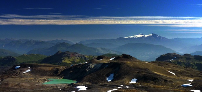
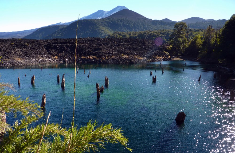
A sub-ice fissure eruption formed the ridge above and to the right of the green lake, with lava sheets and lobes flowing beneath the ice away from the ridge. The distinct snow-capped twin peaks of Mochu-Choshuenco volcano are in the background.
Vent area of the ridge in the above image. Pyroclastic deposits (pale) erupted into a vault within the ice at the start of the eruption. Subsequently capped by agglutinate (welded pyroclasts) and lava-forming effusions as explosive activity waned.
Example of a fissure eruption into ice, with the lava confined near to the vent area by thick flanking ice. This produces an overthickened lava flow that lies close to vent. This emphasises the important role of ice in confining lava flows, especially the more viscous and lower-temperature compositions in the dacite-rhyolite range.
We only have good knowledge of the eruptive history of volcanoes spanning the last 9-12 thousand years – basically since the end of the last glacial period when the ice sheets melted and left the land ice-free. So the carpets of explosive pyroclastic deposits, and the lava flows, have not been destroyed and are therefore available for study. And we have techniques such as carbon dating to tell us when eruptions happened. Some example of recent eruptions at Quetrupillán are below.
Pyroclastic deposits (some reworked) from recent Quetrupillán eruptions. (Holocene for the pedants.)
Young lava flows (dacite if you’re interested) flowing from a fissure. The lava lobe that flowed into Laguna Azul raised the lake level by a few metres. Note the ice-capped summit of the beheaded Quetrupillán stratocone.
A young tuff ring (circular feature in middle ground), formed during an explosive eruption sometime in the past few thousand years. No lava effused from this one, but others have produced lava flows.
Llaima
A US colleague from Boise (Brittany Brand http://earth.boisestate.edu/people/brittany-brand/) asked me to help out on a recce of Llaima volcano with the aim of looking for lava-ice and/or lava-water interactions, as she was running a field trip afterwards. It’s tough finding such evidence in terrain covered with abundant young lava flows, especially as Llaima is one of Chile’s most frequently erupting volcanoes. But I found a few (subtle) examples where lavas had flowed into an old river valley. One is below.
Young lava flow from Llaima showing lava-water interactions. They are a bit subtle, but the curving fractures, the glassy and compact texture, and the block-column structures require additional cooland to form. And the coolant has invaed the lava from above.
A particularly spectacular eruptive unit we also looked at is the Curacautín Ignimbrite, which erupted c.13,200 years ago with a volume estimated at 24 km3. What’s unusual is that this ignimbrite is basaltic to andesitic in composition (50-59% SiO2 for those who are interested). It’s unusual because basaltic-andesitic ignimbrites are very rare – usually it’s the more evolved rocks (dacites and rhyolites) that produce large ignimbrite-forming eruptions. However there are few in this part of Chile, and good old Villarrica has also produced ignimbrites of basalt-andesite composition. It’s fair to say that why these volcanoes have produced ignimbrites of this composition is not fully understood.
The Curacautín Ignimbrite from Llaima volcano. Note the pale-coloured clasts – these are xenoliths of old granite from the basement.
Other beauties of being around Llaima are the lava-dammed lakes, and the ethereal Araucaria woods and forests (commonly known as Monkey Puzzle trees). These trees are highland trees and only feel comfortable growing naturally at elevations above c.1000 metres. There are some beautiful examples growing on the slopes of Llaima, and there’s also areas where the Araucaria forests have been invaded by lava flows.
Young lava flom Llaima (twin-peaked volcano in background) dammed a stream and created this beautiful clear pool, filled with stumps and trunks of dead trees.
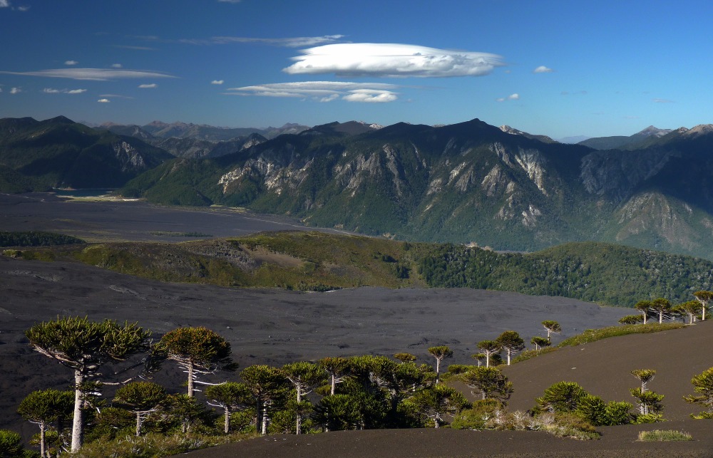
Araucaria forest on slopes of Llaima volcano. Pale granite forms the mountains beyond the lava plains.
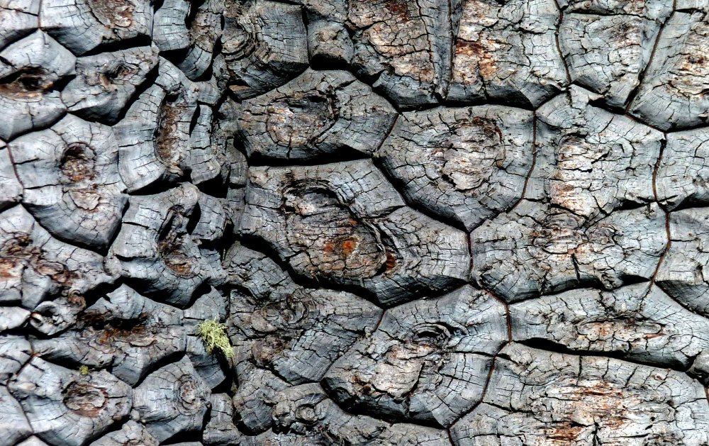
Araucaria bark. Amazing stuff.
Looking forward
To push back the timeline of Quetrupillán’s geological history I’ll be working with colleagues to obtain dates of selected volcano-ice eruptives. When I have some reliable dates and have worked what it all means, I’ll do another blog entry. More about my research and publications can be found at http://www.open.ac.uk/people/dwm4
Acknowledgements
The fieldwork was partly funded by a Santander mobility fund, which is gratefully acknowledged http://www.santander.co.uk/uk/business. As usual, the ever-reliable Rancho de Caballos provided the horses and expert guides to take us up to the volcano with our food and equipment, and came to collect us at the end with our many kilograms of rock samples. http://www.rancho-de-caballos.com/
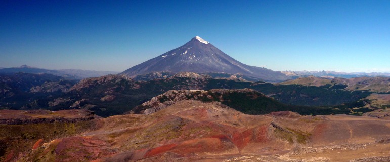
The fabulous Lanín volcano, with an eroded subglacial-emergent flank eruption from Quetrupillán in the foreground (red material – oxidised).
Health warning! I am heading out soon to explore a relatively unknown volcano with a new PhD student but I wanted to put some thoughts down before heading off. It’s a stream of consciousness account. So what you’re going to get here is a lot of text and some links plus some images. There will be a rambling preamble providing underpinning information before I get to what Bárðarbunga might actually do.
I will try and add links and images later. Thought it best to get the text posted first in case I don’t manage to do any more work on this post.
Introduction
The c.15 m subsidence measured at the Bárðarbunga caldera is the largest that has been measured reliably in modern times at any Icelandic caldera IMAGE. And it has been accompanied by a massive release of seismic energy via a series of large earthquakes triggered by the downward movement (along faults) of the inner blocks against the stationary outer rim of the caldera.
And quite rightly there is concern that this large downward movement and major disturbance of the structural integrity of the caldera may lead to an eruption. The problem is that because such an eruption has never been witnessed in the modern era, we really don’t know what will happen. We can take some clues from activity at other volcanoes such as Krafla which has a major volcano-tectonic event in 1975-84 involving dyke intrusion, but at Krafla the caldera did not subside as it is now doing at Bárðarbunga LINK. Askja has a well preserved caldera that formed during a major eruption in 1875 IMAGE, but the amount of subsidence prior to the major eruption is not known with certainty. However the subsidence afterwards was measured reliably and so we know that formation of the present Askja caldera took nearly 40 years. And some subsidence is still happening. (LINK) The amount of subsidence at Askja was considerable, and at 220 m deep the lake formed in the caldera is Iceland’s second largest. If you want to read more about the Askja 1875 caldera formation check out LINK
The Bárðarbunga caldera and other Icelandic calderas
But let’s get back to Bárðarbunga. It has a c.10 km diameter caldera filled with c.700 m of ice. The caldera rims are also covered in ice, so we don’t even get some clues about the compositions of the volcanic rocks erupted here. And this is fairly important, because these rocks could provide clues on how the caldera formed. For example, there’s also a massive ice-filled caldera at Hofsjökull IMAGE, where all of the nunataks (rocky outcrops sticking above the ice surface) on the caldera rim are of rhyolite. From work done by colleagues and myself we know that the effusive phases of rhyolite eruptions into ice form tall towers and ridges because the erupting lava finds it mechanically easier to grow upwards through thinning ice than to try and melt its way sideways through endless ice IMAGES. In essence the ice confines the erupting rhyolite. We also know from studies of well-exposed calderas in other parts of the world that the ‘ring faults’ that are integral to calderas can be leaky, and that it’s not uncommon for lava effusions to escape from these and form domes, which are often of an evolved composition such as rhyolite. Put this process into a subglacial context and hey presto you can create really impressive and tall caldera walls by erupting only a modest amount of lava.
There are other examples in Iceland that corroborate this such as the basalt-dominated caldera walls of the Askja volcano, and the elliptical chains of subglacial rhyolite domes at the Torfajökull volcano. And I’ll finish this list with mention of a most impressive example – the tallest volcano in Iceland – Öraefajökull. IMAGE At Öraefajökull there is a c.8 km diameter caldera filled with up to 500 m of ice, and fortunately there are nunataks on the caldera rim to give us clues. These have not been studied properly, but accounts I have read suggest that most are rhyolite and a few are basalt. The highest point in Iceland – a land dominated by basalt – is ironically the rhyolite dome of Hvannadalshnúkur. The largest explosive rhyolite eruption since Iceland was settled took place from this volcano in 1362 AD IMAGE and the devastation caused to the rich farmland to led to the unusual event of a volcano changing its name, from Hnappafellsjökull to Öraefajökull. Öraefi means ‘wasteland’.
Bárðarbunga caldera and a major eruption
So back to Bárðarbunga (at last, I hear you groan). What it will share with other large Icelandic central volcanoes possessing calderas is a set of sub-circular faults on which upwards and downwards movements takes place to accommodate subsidence and inflation of the underlying plexus of magma bodies (or a large single chamber). Think of a cafetiere of coffee with a leak at the bottom – push it down (subsidence) and the lid goes down and the coffee moves out. Now reverse the process by replenishing the cafetiere via pumping coffee via the leak and the lid will rise up. The cafetiere is the magma chamber, and the lid is the caldera roof. Coffee = magma.
A crucial point is the composition of the magma sitting near the top of the Bárðarbunga magma system. It could be rhyolite, but as the tephra layers representing explosive eruptions from Bárðarbunga are all basaltic let’s assume a large explosive basaltic eruption occurs. Well now we are on reassuringly familiar ground, because back in 2011 we had Iceland’s most powerful basaltic explosive eruption in over a century. Yes, good old Grímsvötn. IMAGE From this we learned a great deal and even though twice as much ash was injected into the atmosphere that Eyjafjallajökull did the year before, the disruption during 2011 was a fraction of that during 2010. If you want to know more and understand more, I can strongly recommend John Stevenson’s blog entries, as he is a top expert on how explosive Icelandic volcanoes may affect northern Europe. LINK So, a worst-case scenario of a large basaltic explosive eruption from Bárðarbunga is something we are fairly well prepared for given the lessons learned in 2010 and 2011. Yes there will probably be disruption to commercial air travel, but for the simple reason that all planes were grounded by law in 2010 and this law has changed means it will never again be as bad as 2010.
What if it’s not a major eruption?
If an eruption at Bárðarbunga happens and it’s not a major 2011 Grímsvötn-type eruption, then what’s likely to happen is one or more eruptions along the ring fractures as magma leaks from below, and depending on the rate and amount of magma erupting, it may or may not reach the ice surface. What is fairly certain though is that any magma that does not escape the ice confines of the glacier will form a tall tower or ridge that will contribute to the caldera structure within the ice.
So there you have it in a nutshell – one worst-case scenario that is less threatening because of we had a similar one in 2011 from Grímsvötn. And other scenarios that are even less threatening to international air travel.
Flooding in Iceland
However any subglacial eruption will produce a lot of meltwater as basaltic magma can (under ideal conditions) melt up to 14 times its own volume, though perhaps 5-10 times is more realistic. This will cause flooding in Iceland which may do damage to the road and power infrastructure. Iceland usually bears the brunt and cost of its volcanic eruptions – 2010 was a rare exception.
Final thoughts – keep an open mind
I have focused only on an eruption taking place at the Bárðarbunga caldera itself. There are other possibilities such as a major eruption in the fissure system to the south-west. But as there is absolutely no current indication of this it’s best ignored. The caldera is in turmoil, and that’s why it’s best focusing on this for now.
Final thoughts 2 – the oddness of subglacial calderas?
I have also revealed via a few tweets and in the above that I consider an important mechanism in the evolution of subglacial calderas in Iceland to be due to a combination of ‘normal’ flexing of the caldera floor in response to subsidence plus upwards growth of caldera rim zones from the icy confinement of effusive eruptives. Other scientists may disagree. That’s not to say that Icelandic calderas cannot also form via major explosive eruptions as happens elsewhere in the world. I am merely pointing out that there’s something special about subglacial calderas that can make them seem much more impressive in their vertical extent without them being formed solely during a single major explosive eruption. After all, there is as yet no evidence that has convinced me that the formation of any major Icelandic caldera is linked to a single cataclysmic eruption….
(Aside. Rhyolite is a rock type that is much more viscous that the basalt being erupted at Holuhraun, and usually contains more gas so it has a higher potential to erupt explosively and produce higher proportions of fine ash relative to basalt.)
Edinburgh has lots of great pubs, and we went to one of my favourites, which is Teuchters in the west end. It always has Jarl which is (as we say in Scotland) a good ‘session ale’. I mention this purely in the shameless hope that the bar staff in Teuchters read this and provide me with a free ale or two.
After that sublime first sip of Jarl the Q&A session continued. I have decided to illustrate some of what we chatted about with a few relevant images. You had to be there to appreciate the artistry on the beer mats and scraps of paper….
Q. So why does this dyke intrusion you told me about not just force its way to the surface and erupt? Is something stopping it?
A. Well the magma in the dyke intrusion is quite ‘happy’ where it is. The magma doesn’t actually have a lot of energy to expend in breaking apart the crust. After all isn’t easier to break apart a rock with a sledgehammer than with a bag filled with gloopy concrete?
Q. I don’t know, I’ve never tried it.
A. Ah, sarcasm. Sup your pint and listen quietly.

The tip of a dyke at Askja volcano that was propagating laterally towards you (i.e. out of the page). Note the start of a ‘split’ in the tip of the dyke. As this widens the two cooler leaves of the dyke move apart and fresh magma squeezes out. It’s likely to be an episodic process (stop-start).
I like to think of magma as being a lazy beast as it will always move to where it’s easiest to do so. So all things being equal, if there’s no easy pathway to the surface the magma will just sit and stew and solidify within the crust. Nobody knows exactly what the crust above the dyke intrusion is like, but if for example it’s a stack of lava flows, then these horizontal slabs of solid rock form a formidable barrier (or lid) on top of the magma.

An example of rifted Iceland crust at Thingvellir. Notice that there’s no single fault but rather a set of faults linked to one or more major faults.
But in Iceland we have rifting and this means that the crust splits in a preferred direction. So there is a pervasive weakness in the Icelandic crust that is especially well developed in the active rift zones, and when a weakness develops and a crack happens to connect underlying magma to the surface, then you get an eruption. Driven by gas expanding and accelerating as the magma ascends to shallower crust and lower pressures. Remember bubbles?
Q. Sigh, you and the bubbles again. Why can’t the magma in your dyke intrusion just go where it wants?
A. If the crust near the dyke is weaker in one direction then this is where the magma will go. That’s why the dyke has been moving towards the NE so far. Now what actually happens around dykes in stress and strain terms is a tad complex, but let’s just say that the dyke wouldn’t have been able to form and propagate unless the crust was already weak in this area. And that the presence of the magma-filled dyke will influence the local stress field and favour some further weakening in the vicinity of the dyke. So although the regional stress field will largely dictate where the magma in the dyke intrusion can go, the dyke itself will have some influence in this.
Q. In simple terms now please? You know how garrulous and nerdy you get when you mix ale and enthusiasm.
A. Where the magma in the dyke intrusion goes is largely dependent on weaknesses in the local crust which are either there already and ready to part, or will appear as this event develops. The magma itself has a say in this, arguably a minor one.

Two dykes intruding fragmented basalt at Askja. The dykes have ‘wavy’ margins because the fragmented basalt was a bit ‘sloppy’ rather than being a brittle solid. Note the prominent chilled margins on the outside of the dykes – a sign that the fragmented basalt was also a tad wet.

Near where the pair of dykes in adjacent image are exposed. High up on Askja’s south caldera wall, looking westwards.
Q. So did you learn about Bárðarbunga from a hurried swotting-up as this event kicked off?
A. I already knew a lot about Bárðarbunga because I did my PhD on the rhyolite-dominated volcano c.100 km to the SW (Torfajökull) where there’s excellent evidence that basalt dyke intrusions in fissures from the NE (i.e. in the direction of Bárðarbunga) had forced their way into Torfajökull and triggered eruptions there of rhyolite (a more viscous and sticky magma type). The last one in c1477 was fairly benign, with minor explosions and two lovely rhyolite lava flows. One of which has a natural hot pool where once can sit and watch the Northern Lights. But I digress. The eruption prior to c.1477 took place in c.874 AD and this led to a powerful and explosive rhyolite eruption. The problem with explosive rhyolite eruptions is that it contains more gas than basalt (hence more bubbles) so it gets blasted apart more. And because rhyolite is less dense than basalt the rhyolite ash is less dense and can get transported further.

1477 AD rhyolite lava flow at Torfajökull (Laugahraun). Grey matter to left is older subglacial rhyolite eruption of Bláhnúkur.

Rhyolite lava flow erupted c.874 AD at Torfajökull (Hrafntinnuhraun). The author in 1983 inside a large bubble (vesicle for the pedants).
The area between Bárðarbunga and Torfajökull is one where massive fissure eruptions have occurred and from where some of the largest flood basalts in Iceland have poured forth. The two recent eruptions (c.1477 and c.874) weren’t as massive, but magma-water interactions with the big braided river to the SW area did produce strings of maars, tuff cones, explosion craters and so on, and consequently lots of fragmented basalt that dammed waterways and created temporary but large lakes.

Large braided rivers in the area between Bárðarbunga and Torfajökull. with subglacial basalt ‘Toblerone’ ridges

One of the flood basalts in the area between Bárðarbunga and Torfajökull. For scale is Professor John Smellie.
I’ve also worked at the Askja volcano to the NE of Bárðarbunga, and so have some idea of how a large basalt-dominated volcano with a large caldera like Bárðarbunga may have been constructed.

From Askja looking over to Kverkfjöll (left) and with the Dyngjujökull glacier to the right, currently considered the most likely place where meltwater from a subglacial eruption will pour forth from.
OK, time for a break while you buy me another ale.
Q. But I bought the first round!
A. Yes, but there’s no such thing as a free tutorial. And remember that my financial prudence has been enhanced considerably after some time living in Yorkshire….
The Science Media Centre (SMC) gathers information from scientists when relevant stories break. I provided them with their first update on Bárðarbunga and they asked me for an update this morning. Thought I’d share this with you.
Current situation at Bárðarbunga
Stable as at 10:30 GMT on 22 August 2014. No sign that an eruption is about to start.
Events on 21 and 22 August have raised anticipation (amongst some) that an eruption is imminent. Given the absence of escalation, these (i.e. summit earthquakes and slight subsidence) are best regarded as normal.
What’s happened so far?
“A magma filled fissure (dyke intrusion) some 25 km long has formed within the crust at 5-10 km depth. Sitting on top of this 25 km strip of crust is ice c.150-350 m thick. This dyke is on the NE flank of the main volcano, which is good news, as eruptions from beneath the main volcano itself have a higher probability of being powerful and explosive enough to generate sufficient fine ash to cause disruption to air traffic. There is no indication that the magma in the dyke is moving upwards, but if it did start moving upward this would heighten the possibility of an eruption.”
The NE flank zone – where magma is on the move
“Should an eruption occur from this flank dyke, the eruption style will be influenced by the presence or absence of ice above the eruption site, how much magma erupts, and the rate at which magma erupts. The likelihood of the magma currently in this dyke erupting to produce a substantial enough ash cloud to seriously affect international air travel is zero.
In summarising the flank dyke scenario, if this dyke grows at a similar (slow) rate to that of recent days, then it will either stall in the crust where it will cool and solidify, or it will gain access to the surface and erupt. A modest eruption is likely, with spectacular local explosions generated via interactions between magma and ice/water being observed unless the eruption is wholly covered by ice. Any subglacial eruption generates considerable amounts of meltwater as erupting magma can melt more than 10 times its own volume of ice (NB. variable – depends on conditions).”
Local flooding
“The authorities in Iceland have taken the precaution of evacuating everyone from an area where they would be cut off should a vital bridge be destroyed during a flood. The bridge crosses one of Iceland’s largest and most powerful rivers, and so authorities have alerted communities downstream of action they should take in the event of a flood. It should be noted that unlike the spectacular Amazon River sized flood following the subglacial Gjálp eruption of 1996, as there is no similar sub-ice topographic receptacle near the dyke intrusion in which to store meltwater till it escapes in one massive pulse, meltwater should escape rapidly and continuously from underneath the glacier which will help with managing and mitigating the effects of the flood.”
One worst-case scenario
“Although there are a number of ‘worst-case’ scenarios, one worth mentioning (because it is naturally on everyone’s radar because of the Eyjafjallajökull eruption) is a large and powerful explosive eruption from the main volcano itself that produces a sizeable ash cloud. I must stress that this is not even on the horizon at the moment – it’s somewhere well off the edge. Powerful and explosive eruptions from Iceland’s volcanoes are well documented, and there are many of them. Put simply, Icelandic magma contains enough gas to drive powerful explosive eruptions. The most recent unequivocal evidence of this was the 20 km high eruption plume produced during the 2011 eruption of Grímsvötn. Evidence from ash layers in Iceland indicates that powerful explosive eruptions have occurred in the past from Bárðarbunga.
“The good news is that if a powerful and explosive eruption does happen, then the experience gained during the 2011 Grímsvötn eruption (which involved a relaxation of the rules for flying with volcanic ash in the atmosphere), would result in a carefully managed strategy to minimise the number of flight cancellations and diversions. Despite erupting twice as much ash as Eyjafjallajökull 2010, flight cancellations during the Grímsvötn 2011 eruption were less than 1% of the number of flights cancelled during the Eyjafjallajökull 2010 eruption. An important factor in reducing the number of flight cancellations in 2011 was a wind direction that was favourable to UK and western Europe.
“In summarising the large and explosive eruption scenario, there are NO indications that this is about to happen. Even if it does happen we would not get a repeat of the disruption caused by the 2010 Eyjafjallajökull eruption, simply because if this same eruption happened tomorrow there would be far fewer flight cancellations (due to revised flight rules, better information on ash concentrations, and experience gained during 2010 and 2011).”
Concluding note
“Finally, volcanoes are complex natural systems, and when we know so little about a volcano such as Bárðarbunga because it hasn’t erupted in the modern era and thus we have no prior understanding of how it behaves when it stirs, it’s difficult to anticipate what might happen. If this current event does not last long then it will be a volcanic speed dating experience. If it lasts longer, then we may get to know Bárðarbunga’s volcanic personality a little better.”
Yesterday a colleague decided to hold a ‘mock’ interview with me during our lunch break, which she recorded and I’ve just written up and tidied up. You may find it informative.
Q. So Dave, stop the 50:50 stuff when asked ‘will it erupt’. What do you really think?
A. It’s still 50:50! Whether it will erupt or not depends on a number of factors, some of which cannot be monitored. So that people can better understand why predictions are so difficult let me list some:
The magma is sitting at depth in a vertical fissure and slowly moving NE. It’s a dyke intrusion.
A key question is whether new magma is joining the magma in the dyke. If not (or it’s just a small amount), then there is unlikely to be an eruption. It will stall and cool.
However should a fracture suddenly appear above the dyke, then the magma is going to move upwards, and then it’s more likely to erupt.
Because as it moves up, it will reach a level where any dissolved gases (mostly water) will stop being dissolved, expand dramatically and accelerate upwards, and ‘push’ the magma to the surface. This is actually how eruptions are powered – bubbles.
Another scenario is if magma keeps being pumped into the dyke. The dyke has a number of choices: use the extra energy to keep moving NE; expand by moving to the SW, or grow up and/or down.
Get the picture?
Q. Thanks Dave, and stop calling me Bubbles. Right, we all love an apocalyptic story, so what’s the worst case scenario?
A. Ah, well, there’s more than one with this particular volcano – sorry. But these are nowhere on the horizon at the moment. Here are three.
- This presently benign little dyke intrusion is the forerunner to the uprise of large packets of melt from below (from the mantle) and it suddenly turns into a Laki-type flood basalt eruption. There’s still controversy over how these massive eruptions are fed in Iceland, but they always occur in fissures, and they have to involve the mantle because we have no definitive evidence that 10s of cubic kilometres of melt are stored under each central volcano just waiting to erupt. A little puzzle to solve is why these flood basalts (if they are fed directly from the mantle) have ‘shallow’ pressure signatures, but this might just mean they spend enough time at shallow dept in transit to ‘equilibrate’ to lower pressures.
- This event triggers activity within the heart of Bárðarbunga, beneath the summit, where there’s almost certainly some melt and or mush (melt+crystals) stored. This could be all basalt, or there could be some more ‘sticky’ magma around, such as rhyolite. Evidence from ash layers in Iceland indicates that explosive basalt eruptions from Bárðarbunga do happen, and that they are powerful. The good news is – and myself and John Stevenson have said this many times – is that we have less to worry about if this happens because we’ve already had one – Grímsvötn 2011. So we know that fewer flights will be cancelled simply because the old “ash in the sky you don’t fly” rules no longer exist. Everyone is much better prepared for a big and powerful explosive eruption. I’ve seen a few geologists say things like “Icelandic magmas do not contain enough gas to drive powerful explosive eruptions”. This is utter rubbish, incorrect, and misleading. These are invariably geologists who lack a true understanding of Icelandic volcanism because they have done little or no research there.
- Probably the worst-case scenario for Iceland is that this leads to a massive volcano-tectonic event in the fissure system to the SW of Bárðarbunga, as this is where a number of large flood basalt eruptions have occurred. The hydroelectric power plants on the rivers near to this fissure system would be in trouble, and we know that in the past large ash piles have dammed the rivers. The abundant water in this area results in spectacular (but fairly local) explosions and a high production of fragments as the abundant river water cools the erupting magma.
Q.Final question. You mentioned over coffee that you’d been very active on Twitter trying to get what you called the ‘right information’ out there. But isn’t there a danger that others will pinch your work and re-cast it as their own?
A. That comes with Twitter territory. I’d much rather try and provide an informed and scientifically-based set of views and ideas that can be pillaged and re-used (usually without credit) than leave it to those who don’t understand Icelandic volcano-tectonics to mislead (not always deliberately I hasten to add). I appreciate it when folks give me credit, but I don’t expect it. If you are being paid from public money to do your science, then put your knowledge to good use for the benefit of the public. Getting credit for it is a bonus, not a right.
Q. OK – late for the next meeting Dave. Maybe continue with a pint or two later?
A. Only if it’s a real ale acceptable to my palate.